
This Article From Issue
July-August 1999
Volume 87, Number 4
DOI: 10.1511/1999.30.0
Two years ago, on the first of July, residents of Minneapolis saw Midwest summer weather at its ugliest. According to the Minneapolis Star-Tribune, the skies turned a "surreal" shade of black and green as a squall line moved toward the city. In just half an hour, three inches of rain doused parts of the city. A foot of water rushed into the Mall of America, and a power outage forced doctors in one hospital to deliver babies by flashlight.
To the northwest, things were a whole lot worse. Twelve tornadoes rampaged through the surrounding counties, knocking down houses by the hundreds and trees by the thousands. The town of Monticello, the Star-Tribune reported, looked like a logging camp. "There were no fatalities—amazingly," says Gregory Tipton, who at the time was a journeyman forecaster in charge of reading the Doppler radar at the National Weather Service bureau near Minneapolis.
American Meteorological Society
Ad Right
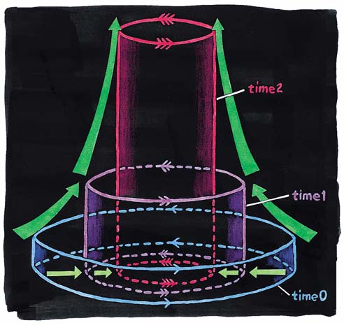
There was little warning for these tornadoes because, according to Tipton, the July 1 storm fooled meteorologists. Most of its tornadoes formed from the ground up—the opposite of a textbook tornado, which is supposed to descend from the clouds. The standard model of tornado development invokes the "dynamic pipe effect." In this model, a tornado gets started three miles or so above the ground with the formation of a broad vortex up to several miles wide, called a mesocyclone. Within the vortex air converges into smaller eddies, and as it converges it starts spinning faster, in the same way that a figure skater spins faster when she pulls in her arms. Eventually, the rotating air column becomes condensed enough to form a barrier that keeps any more air at its own level from getting in. Then the vortex has to suck air in from below. This, in turn, causes the air at the lower levels to circulate faster. Eventually the barrier moves down to the lower levels, and the column of spinning air (the "dynamic pipe") grows longer. It's a fairly slow process, so forecasters usually have about 20 minutes from the appearance of the first eddy on their radar screens until the touchdown of the tornado.
But in a forthcoming study of tornado patterns all over the country, nearly half the tornadoes failed to conform to the dynamic-pipe model. These "nondescending" tornadoes, which form either from the bottom up or at all heights simultaneously, are more likely to be associated with squall lines, as the Minnesota tornadoes were, and they give much less advance warning of their presence than the typical top-down tornado.
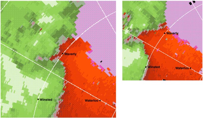
Tom Dunne; adapted from Journal of Atmospheric Sciences.
Three years ago, Jeffrey Trapp and Robert Davies-Jones of the National Severe Storms Laboratory in Norman, Oklahoma derived a mathematical model that explains how a tornado can grow from the ground up, describing their work in the Journal of Atmospheric Sciences. If air within the mesocyclone starts to converge first at ground level (Trapp says the formation of the mesocyclone at ground level is "still hotly debated"), then updrafts resulting from the buoyancy of hot air can stretch the vortex upward. As it stretches, it becomes narrower, and (think of the figure skater again) spins faster and faster. In as little as five minutes, according to computer simulations, it can spin up to a full-fledged tornado.
To see how often this behavior is actually observed in the field, Trapp went to DeWayne Mitchell, the developer of the Tornado Detection Algorithm now installed on all Doppler radar stations nationwide. "Someone on the ground would not be able to distinguish a tornado that formed on the ground from one that formed aloft," explains Mitchell. The visible shape of a funnel cloud depends on the debris it collects and the condensation point of water, and not directly on the winds that give it birth, which might be quite invisible. They are not invisible, however, to Doppler radar. The telltale sign is an intense wind shear, created as the air on one side of the funnel moves toward the radar station and the air on the other side moves away.
Even with Doppler radar, though, a ground-up tornado can be tricky to detect, because the line of sight of radar gradually rises with distance. From a distance of 100 miles, radar cannot detect anything less than a mile high and thus misses anything happening near ground level. To get around this problem, Trapp and Mitchell pared down an existing storm database to confirmed tornadoes that passed within 75 miles of a Doppler radar station. To avoid a "Tornado Alley" bias, they also picked tornadoes from various areas of the country. Out of the 52 storms they analyzed, they found that 25 fit the "nondescending" profile. Their study will appear later this year in Weather and Forecasting.
None of the storms studied by Trapp and Mitchell were as powerful as the half-mile-wide tornado that killed 38 people in the Oklahoma City area this May 3. Forecasters spotted that tornado well in advance, issuing a warning 25 minutes before it struck the city. Although meteorologists don't know yet whether ground-up tornadoes can get that strong, Mitchell says it is safer not to assume they can't. "We have essentially no skill at forecasting the strength of tornadoes," Mitchell says. Therefore, he says, forecasters must treat every tornado as "potentially devastating."
Because nondescending tornadoes develop so quickly, there may be little that radar can do to issue a warning earlier. Five minutes is just the length of time between two sequences of Doppler radar sweeps, so a new tornado can brew up literally while the radar is looking the other way. In such cases, the judgment of the meteorologist—who also has satellite and spotter reports, and the benefit of years of experience—may be key. "This person always plays second fiddle to the Doppler radar," Tipton says. "In my opinion, they should be spoken about as equals."—Dana Mackenzie
American Scientist Comments and Discussion
To discuss our articles or comment on them, please share them and tag American Scientist on social media platforms. Here are links to our profiles on Twitter, Facebook, and LinkedIn.
If we re-share your post, we will moderate comments/discussion following our comments policy.