Small-Town Story
By Brian Hayes
What factors arrange cities and towns on a map?
What factors arrange cities and towns on a map?

DOI: 10.1511/2004.46.115
It's human nature: We huddle together in densely packed communities and then complain, Yogi Berra–style, that it's too crowded here. The vast rural-to-urban migration of the past two centuries has left much of the countryside all but vacant. And yet people have also been fleeing the central cities; places such as Buffalo and Cleveland have lost almost half their population. The majority of Americans now live neither in the country nor the city but in the suburban areas of metropolitan counties. It's a slightly puzzling pattern: If we all choose to live near a big city but not in it, who will make the city big?
The waves of population sloshing back and forth between farm and city also wash over the smaller towns and villages of the rural landscape—and perhaps threaten to wash them away. The market towns of the agricultural Midwest and Great Plains are considered especially vulnerable to these demographic tides. A recent series of articles in The New York Times discussed the fate of four such towns under the heading "Vanishing Point: The Empty Heartland." Those articles were hardly the first to note the plight of rural towns; indeed, an essay by Henry J. Fletcher was already predicting "The Doom of the Small Town" in 1895. It's another puzzle: If the towns were doomed 100-plus years ago, how is it they are still in the process of vanishing today?
Some quantitative insight comes from American Agriculture in the Twentieth Century: How It Flourished and What It Cost, a 2002 book by Bruce L. Gardner of the University of Maryland. Gardner summarizes data from several studies of incorporated communities with a population of 1,000 or less. (Only incorporated towns are included because that's what the Census Bureau counts.) It turns out the number of such towns was roughly the same in 1990 as it was in 1910—about 9,500. Of course they are not all the same towns; many have come and gone, and the total number has fluctuated to some extent over the decades. Another study gives a more detailed view for the years from 1940 to 1960, which was the era of steepest decline in farm population. Of 10,099 towns in the under-1,000 category at the start of this period, 8,363 were still on the list at the end, for a loss of 1,736. But only 303 of those missing towns dwindled away to nonexistence; the rest departed the data set not by shrinking but by growing beyond the 1,000-person cutoff. Meanwhile, another 271 towns crossed the boundary in the opposite direction, declining from a larger population to under 1,000. And 1,236 towns in this size class were newly incorporated during the period. The net change resulting from all of these events was a loss of 229 towns, or about 2 percent. These numbers don't seem to support the notion that the small town as a social institution is about to dry up and blow away. If anything, what needs explaining is the remarkable stability and resilience of these communities. In the aggregate they seem to have survived almost unchanged through an unprecedented demographic upheaval.
Threats to the well-being of small-town America certainly seem plausible enough. As the surrounding farmland is drained of population, merchants on Main Street lose their customers. When those businesses close, jobs go with them. The tax base erodes, so that schools and other services deteriorate, causing still more people to move away. The mobility provided by roads and automobiles is another often-cited factor. Because people can travel farther for routine errands, local shops find themselves in competition with the Wal-Mart in the larger town up the road.
NOAA Defense Meteorological Satellite Program
Some of the same developments that put small towns in jeopardy, however, might also sometimes work to their benefit. With all those millions of people leaving the farm, a few might be expected to settle in nearby towns; after all, not every former farmer goes off to Silicon Valley to be a dot-com entrepreneur. Improvements in communication and transportation could also cut both ways; people can live farther from their work and may be enticed by outlying villages. Jobs themselves have also diffused beyond the urban core; thousands are employed in places like Georgetown, Kentucky, and Dodgeville, Wisconsin. Even cultural attractions are no longer so centralized; you can live in the sticks and still get to the multiplex. And market economics is surely at work: A four-bedroom house with Victorian gingerbread trim is more affordable in a Minnesota village than in Boston or San Francisco. Finally, there is the indefinable matter of preferences: Even though most of us now live in metropolitan areas, opinion polls indicate that a majority would prefer rural or small-town life.
A coherent interpretation of all these conflicting trends and forces is not something that's likely to emerge from casual computer modeling. Rural sociologists have been striving to understand the situation for 50 years and more. (In particular, I would call attention to the work of Glenn V. Fuguitt of the University of Wisconsin at Madison, and his students and collaborators.) In spite of extensive fieldwork and careful analysis, there is no consensus about what's in store for America's small towns, and there is no predictive theory.
Although computer simulations will not explain human settlement patterns, perhaps such models can reveal something about what needs to be explained. There may be murky psychological forces at work, but before invoking them it would be useful to know whether any of the observed patterns of migration might be accounted for by simpler mechanisms. An analogy from animal behavior comes to mind: the ant graveyard. Some species of ants tend to gather all their dead in one place, a practice that might seem to require considerable planning and organization. But simulations show that a simple two-part rule will suffice: If you see a dead ant and you're not already carrying one, pick it up; if you see a dead ant and you are carrying one, put yours down near the other. The rules that govern human decisions about where to live are surely not as simple as these, but it's worth seeing what can be accomplished with the most obvious algorithms.
Population change has two components: natural increase (the excess of births over deaths) and migration (the number of people moving in minus the number moving out). For the purposes of this article, however, I shall ignore natural increase altogether and pretend that total population is a conserved quantity. Thus only migration matters, and one town's gain is necessarily another's loss.
The simplest of all migration models sets people wandering randomly from place to place. But what does it mean, exactly, to move randomly? Here's one algorithm: From the set of all towns, choose one in such a way that every town has the same probability of selection; call the chosen town the source, S. Now pick a second town, the destination, D, in the same way. Move one person from S to D. (Occasionally S and D will turn out to be the same place, but that's okay.)
When you repeat this process many times, what happens? Looking at the distribution of places according to size, the result is more realistic than we have any right to expect from such a primitive model. In round numbers, the U.S. has 20,000 incorporated places, which are home to 250 million people. If that population sorted itself out according to the algorithm above, the largest cities would have roughly 100,000 residents, and a fifth of all the places would be villages of 1,000 people or less. The actual distribution is steeper—with bigger big cities and more small towns—and yet the overall shape is similar. Even this partial success is something of a surprise, because the underlying assumptions of the model are quite implausible. In choosing a source or destination, it assigns the same probability to a North Dakota hamlet as to New York City.
A remedy for this distortion is to weight the probability of selecting each town according to its population. An equivalent way of formulating the same process is to choose a person—rather than a town—randomly and with uniform probability. The selected person will be the migrant. Now choose a second person in the same way, and let the migrant move to wherever this second person resides. Under this procedure, people everywhere have the same probability of moving, which is surely closer to the truth than the heavily biased scheme of the first model. But now another peculiarity turns up. If the population of a town ever falls to zero, that place can no longer be chosen either as a source or as a destination; in effect it is permanently removed from the model. What's more, such extinctions are inevitable. If you track the evolution of any one town's population, it executes a random walk on the integers, moving up or down by one step each time someone arrives or departs. Any such random walk must eventually reach the zero point. Thus the unavoidable outcome, if the model runs indefinitely, is that every town but one will shrink to nothing, and the entire population will be crammed into the one surviving Omniopolis.
In a 1965 paper Fuguitt analyzed another probability process, which is quite different in detail but has a similar end point. Instead of directly simulating movements of people, he took as a fundamental event a town's transition from one size class to another. Using probabilities derived from Census data (and allowing for natural increase as well as migration), he found that eventually all towns would grow until they entered the largest class.
The runaway behavior of these models could be avoided in various ways—by a mechanism for creating new towns to replace those that dwindle away, by introducing subpopulations with different preferences in residence, or perhaps by building in an economic incentive favoring less-crowded areas. But such embellishments also bring more adjustable parameters, and the models no longer look so simple.
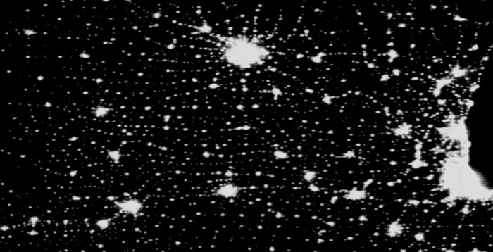
Something missing from all the models above is geography. There is no concept of distance; each town interacts with all the others on the same basis. On a real landscape, nearby towns are surely coupled more tightly than distant ones. A strong hint of spatial organization in the distribution of town sizes comes from the dramatic nighttime photographs of the Earth's surface made by the Defense Meteorological Satellite Program. The instrument that records these images is a sensitive photodetector meant to measure cloud cover by moonlight, but it can also record city lights. A study of the photographs done by Paul Sutton of the University of California, Santa Barbara and three colleagues failed to establish a precise calibration of pixel brightness to population density, but distinguishing large and small towns is easy.
In a satellite image of the upper Midwest and Great Plains, it's obvious that the scattering of towns and cities is anything but random. In some areas, strings of towns seem to radiate from major population centers. Elsewhere the pattern reflects the rectilinear network of roads, which in turn derives from the early surveys of the territory based on uniform square townships six miles on a side. Of course the lattice of towns is nowhere perfect, but there's enough regularity that it leaps to the eye.
NOAA Defense Meteorological Satellite Program
There is more to the spatial distribution of towns than just the latticelike arrangement of sites. Each category of settlement—the hamlets, the villages, the towns, the cities, the conurbations—appears to have its own characteristic scale of distance. Progressing from smaller to larger settlements, the spacing increases. At the same time the lattice structure becomes less regular.
There's an easy hypothesis to account for the general features of this pattern, assuming that the siting of towns and cities is determined mainly by their role as service centers for a dispersed population. People want someplace nearby where they can mail a letter or pick up a quart of milk, but they are willing to travel farther for less-frequent errands, such as shopping for clothing, and they'll go farther still to buy a new car or see an art exhibit. Thus each category of settlement competes mainly with others of similar size, and the interstices between major centers can be filled in by smaller towns. Ecologists have observed a similar pattern in the distribution of desert plants, where the largest shrubs maintain a fixed distance from one another, determined by the size of the catchment basin needed to sustain their growth; smaller plants can survive in the open areas between the bigger bushes.
This biological analogy suggests one way to model the spatial distribution of towns: Let people be sprinkled over the landscape like rainfall and drain into the nearest basin; then each basin's radius of attraction grows along with its population. Another approach takes its inspiration from physics rather than biology. The geographic distribution of towns looks a little like the arrangement of atoms or molecules in a mildly disordered material, such as a glass. This observation suggests the metaphor of a repulsive potential between towns, as if there were springs holding them apart. From any starting configuration we can then allow the network of springs to relax to a state of lower total energy.
Yet there's something odd about this idea. In a model of a solid, the network of springs relaxes by adjusting the positions of the atoms. Towns and cities, however, seldom get up and move. Even if, say, Austin and Rochester, Minnesota, would both be better off if they were a few miles farther apart, there's no convenient way to slide them across the landscape. Instead, the towns stay put, and all adjustments have to be made by having people migrate from place to place.
Here is an algorithm (one of many possibilities) for constructing such a model. At each step, choose two towns at random with uniform probability. Calculate the repulsive interaction between each of these towns and all the other towns in the sample, using some sort of potential in which the repulsion increases with population and diminishes with distance. The sum of all these interactions can be interpreted as an energy. Now move a person from one town to the other in whichever direction lowers the overall energy. Then start over by choosing two new cities.
The details of the inter-town potential are where the model gets messy. An obvious starting point is "antigravity": The force between two towns is directly proportional to the product of their populations and inversely proportional to the square of their distance. (It is antigravity because the force is repulsive rather than attractive.) Unfortunately, letting the system evolve under such a potential does not yield a realistic geography. The problem is that large cities not only repel one another but also strongly suppress the population of nearby smaller towns and villages, creating a vacant buffer zone that has no counterpart in the real world. A straightforward correction is to include another factor in the inter-town potential, namely the ratio of the smaller to the larger population. If this ratio is 1 (that is, the two towns have equal populations), then the repulsion will take its full strength. As the ratio approaches 0 (for the case of a one-stop-sign hamlet and a metropolis), the two places become almost oblivious of each other's presence.
The device of scaling the repulsive force according to the ratio of populations has a curious mathematical consequence. The force becomes proportional to pq x p/q (where p and q are the two populations, and p ≦ q).
This expression immediately simplifies to p2; that is, the larger population drops out of the calculation altogether, and the force between the towns depends only on the smaller population. Viewed in terms of a physical force law, this irrelevance of the larger population seems strange; it's certainly nothing like gravity. But it makes sense if we return to the original motivations for the model. We assumed that a hamlet can survive if and only if it is the closest place to buy milk or mail letters for everyone within a certain radius. Beyond that distance, it doesn't matter whether the next-nearest town is another tiny village or the city of Chicago.
A model constructed on these principles can be made to yield landscapes that visually have many of the same properties as real town-and-city distributions. A convenient starting configuration is a rectilinear grid of town sites, "jiggled" slightly to break the symmetries, with all the sites assigned the same starting population. Of course the towns never move; only their populations change as people transfer from site to site to reduce the energy of the system. After running the simulation for a few thousand steps per site, migration has altered the populations in such as way that villages, towns and cities are all distributed at the appropriate length scale. The smallest places are densely packed, whereas larger ones keep a greater distance between them.
It should be pointed out that this model is susceptible to the same demographic black-hole problem seen in the random-walk models. The lowest-energy state of the system is the configuration that packs everyone into a single city, since that eliminates all forces between towns. But the relaxation algorithm described above is unlikely ever to find this solution; it is a "greedy" algorithm that almost always becomes trapped in a metastable state. Here is a case where a "better" algorithm—one that converges to the true optimum—would not necessarily improve the model.
Could migration models as simple as these ever be made to give reliable and accurate predictions? This is a question not just about the models but also about the system being modeled. Similar techniques work quite well in the physical sciences and in some areas of biology—such as the case of the ant-graveyard problem. But we tend to see human habits as more complex and more contingent than any behavior of atoms or ants, and therefore beyond the scope of algorithmic or mathematical rules. After all, ants have been following the same basic impulses for millions of years, and furthermore they don't read American Scientist articles about ant behavior. Our own actions, in contrast, are influenced by familial, social, economic, historical, technological and cultural forces—not to mention sheer orneriness and whim. Whatever brings people to small towns today, it seems unlikely to be the same factor that acted on their parents or grandparents.
And yet the very survival of all those out-of-the-way communities from one generation to the next argues that human actions are not quite as fluid and contingent as they seem. There must be some regularity or consistency in our choices, even if we are not fully aware of it. A conservation law seems to be at work, or at least a stabilizing feedback principle. Computational models may offer our best hope of discovering the structure of such laws.
© Brian Hayes
Click "American Scientist" to access home page
American Scientist Comments and Discussion
To discuss our articles or comment on them, please share them and tag American Scientist on social media platforms. Here are links to our profiles on Twitter, Facebook, and LinkedIn.
If we re-share your post, we will moderate comments/discussion following our comments policy.