Detecting Irregular Gravity
By Catherine Clabby
The Gravity Recovery and Climate Experiment (GRACE) mission, a collaboration by NASA and the German Aerospace Center, captures variation in Earth's gravitational pull
The Gravity Recovery and Climate Experiment (GRACE) mission, a collaboration by NASA and the German Aerospace Center, captures variation in Earth's gravitational pull

DOI: 10.1511/2010.84.236
You are forgiven if you assume that Earth’s gravity is uniform all over the globe. Most people probably do. But Earth’s variable mass results in differences in the planet’s gravitational tug. Launched in 2002, the Gravity Recovery and Climate Experiment (GRACE) mission, a collaboration by NASA and the German Aerospace Center, captures such variation and how it changes over time. Two synchronized satellites on the same orbital plane constantly record minute changes in the roughly 220-kilometer distance between them. The gap shifts slightly as the mass in the ground beneath the satellites changes, with higher densities pulling one spacecraft away from the other. Project scientist Michael Watkins at the Jet Propulsion Laboratory in Pasadena, California told American Scientist associate editor Catherine Clabby what GRACE has revealed so far.
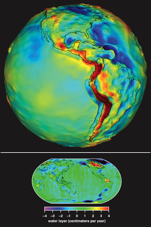
(Top image courtesy of NASA/Goddard Space Flight Center. Bottom image courtesy of The University of Texas Center for Space Research.)
A.S. What was innovative about GRACE’s design?
M.W. GRACE is the world’s first mission designed specifically to measure the Earth’s gravity field at high accuracy. Most importantly, the team realized that the gravity isn’t just something you measure once, as most people had thought. By watching changes in the gravity field, we can learn about large-scale, climate-related changes in the Earth’s complex water cycle. Those changes primarily move the mass of water around, which we can track through their effects on the gravity field. These phenomena are difficult to observe with any other remote-sensing technique, which is what makes GRACE unique. The main technical enablers were the development of advanced tracking systems, both the Global Positioning System (GPS) and the microwave signals between satellites; the development of precision accelerometers; and general progress in development of small satellites. The “pixel size” GRACE can capture is a few hundred kilometers across.
A.S. How do you ensure that all you are measuring is Earth’s gravity?
M.W. We fundamentally measure the gravity by how it affects the orbits of the satellites, which we measure by both GPS technology and directly tracking the distance between the two satellites. There are a handful of small changes in the orbits that are not due to the gravity, like a tiny residual amount of atmospheric drag, even in space. We measure those with one of the world’s most accurate accelerometers, which was built by colleagues in France. Finally, we account for the effect of the Moon, Sun, planets, tides—all those things. Because the data analysis can get fairly complex, we generally use supercomputers to get it done.
A.S. Has GRACE produced any surprises?
M.W. The extent of mass loss in polar ice in Greenland, Alaska and West Antarctica surprised many people. The total has been in the hundreds of gigatonnes per year. Similarly, the depletion of groundwater in several areas such as northwest India was larger than expected. In addition, the very large earthquake in Sumatra in 2004 was large enough to be detected by GRACE, which provided interesting geophysical information about the quake.
A.S. What has GRACE clarified?
M.W. I would say mostly how climate changes affect the large-scale movement of water around the globe, which we didn’t know well before. We also learned a few things about the long-term average field, which helps oceanographers analyze radar altimetry data. We’d like to get the resolution down from a few-hundred-kilometer “pixels” to something smaller, which would help us observe groundwater changes in smaller river basins and small ice streams.
A.S. What is GRACE expected to achieve in the future?
M.W. GRACE will continue to extend the duration of our observations of the Earth. One thing that makes climate research so difficult is the number of things occurring at once in the Earth system. It takes time to sort out the incredibly complex interactions of ocean, atmosphere and biosphere. It’s difficult to do that with only a few years of data. Many scientists say decades of data are a necessity.
In Sightings, American Scientist publishes examples of innovative scientific imaging from diverse research fields.
Click "American Scientist" to access home page
American Scientist Comments and Discussion
To discuss our articles or comment on them, please share them and tag American Scientist on social media platforms. Here are links to our profiles on Twitter, Facebook, and LinkedIn.
If we re-share your post, we will moderate comments/discussion following our comments policy.