Tracking the Karakoram Glaciers
By Catherine Clabby
A photographer creates images of present-day glaciers from the same vantage point as that of historic photographs
A photographer creates images of present-day glaciers from the same vantage point as that of historic photographs

DOI: 10.1511/2010.83.156
In 2009, Italian outdoor photographer Fabiano Ventura began “On the Trails of the Glaciers,” a project duplicating early 20th-century expeditions to remote mountain glaciers. Ventura’s first stop was the Karakoram range, 16,500 square kilometers of glaciers and peaks that include K2, Earth’s second-highest mountain. Spanning parts of China, India and Pakistan, the Karakoram range is the most heavily glaciated area outside this planet’s polar regions. During a 1909 Italian expedition, photographer Vittorio Sella took numerous much-admired photographs there. Ventura’s new images were taken from the same point of view as the historical images to enable direct comparisons for research purposes. The photographs could help scientists observe developments in glaciers related to global climate change. American Scientist associate editor Catherine Clabby discussed the scientific value of the first stage of Ventura’s project with Kenneth Hewitt of Wilfrid Laurier University in Canada. An expert on Karakoram glaciers, Hewitt is a member of the project’s scientific committee.
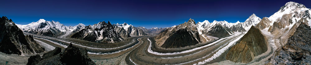
Fabiano Ventura 2009/www.fabianoventura.it
A.S. Have glaciers in the Karakoram range been well studied?
K.H. The glaciers have been studied mainly in a few relatively extensive expeditions. The earliest were over 150 years ago and provide some basis for comparison. The 1909 Italian expedition brought a huge leap forward with mapping, observations along many of the high-altitude source areas of Baltoro glacier, and the outstanding photographs of Vittorio.
A.S. The Karakoram glaciers display changes since 1909 that you and other scientists associate with climate change. Yet the differences are not the dramatic shrinking and melting observed elsewhere. Can you explain that?
K.H. Glaciers are diminishing in most parts of the world, and reports of “disappearing glaciers” have come from much of the Himalaya region, but not the Karakoram. Total glacier cover there diminished by about 10 percent during the 20th century, but since the late 1960s there has been little change. Recently, many glaciers in the higher parts of the range have thickened and advanced. There have been exceptional numbers of glacier surges—sudden, rapid advances of some kilometers in a few months. The responses certainly reflect climate change, but they are regionally distinctive responses. The advances appear to relate to negative feedbacks in the glacier environment involving increased snowfall or reduced melting or both. The evidence is largely indirect or model-driven, but several research efforts using satellite imagery suggest both increased snowfall at higher elevations and more storminess and cloud cover in summer, which may reduce melting. If the apparent anomalies result from a warming globe, it suggests more moisture is transported from warmer oceans to the highest mountains. Once there, it either nourishes the glaciers with increased precipitation or protects them from some melting with more frequent cloudiness.
A.S. Do these glacier advances and surges pose dangers to people dwelling closest to the Karakoram?
K.H. Given the loss of glaciers elsewhere, sustained glacier mass in the Karakoram may seem good news, and in certain respects it is. But advancing glaciers also bring dangers. They brought hazards and disasters during the Little Ice Age, that period of global cooling that persisted in this region until the early 20th century. Hazards back then included glacial lake outburst floods that reached the heavily populated lowlands. Ice dams from advancing glaciers off the northern flanks of K2 remain a threat on the upper Yarkand River. Surges and terminus advances are confined to the higher parts of the range where they can block paths but rarely reach inhabited areas. The greater danger comes from ponds of water created during glacier advances or within stagnant ice after the surges end. Outburst floods from these ponds are especially destructive where they entrain sediment and become debris flows. Because the mountains straddle three countries, transnational as well as local and national issues arise. About one million people live along the upper Indus streams in the Karakoram and nearby ranges. Tens of millions live downstream in the Indus and Yarkand River lowlands, where snow- and ice- melt waters dominate river flows.
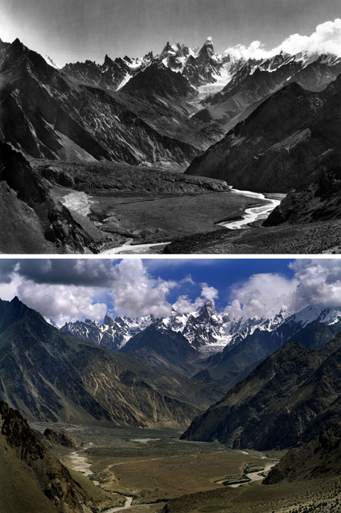
(upper image) Vittorio Sella 1909/© Fondazione Sella (lower image) Fabiano Ventura 2009/www.fabianoventura.it
A.S. How are Fabiano Ventura’s photographs of these glaciers useful to scientists?
K.H. Observations of changes in glaciers over a century or more are an invaluable first indicator of what has happened and what needs to be explained. We can see detailed variations in the margins and surface features of glaciers in these photographs. The Baltoro glacier is barely 300 meters shorter than in 1909, but the Biafo glacier is 3,500 meters shorter. The two glaciers are in the same part of the range, of similar size and length. However, Biafo is fed mainly by direct snowfall in the huge open basins at its head, while Baltoro is largely avalanche fed and has a much higher, more rugged watershed. There are indications that a higher watershed, avalanche nourishment and heavy debris cover produce a more conservative response to climate change—and these effects apply to all glaciers advancing at present. High-resolution photography can also extend analysis of glacier changes to otherwise inaccessible areas. It supplements satellite imagery, some of which is amazing, but which is restricted to the recent past and not so good for observing vertical changes. The higher the resolution of images taken now, the greater the usefulness of photography for tracking future changes.
For more information about “On the Trails of the Glaciers,” including updates regarding a documentary and a photography exhibit, visit http:// www.sulletraccedeighiacciai.it
In Sightings, American Scientist publishes examples of innovative scientific imaging from diverse research fields.
Click "American Scientist" to access home page

American Scientist Comments and Discussion
To discuss our articles or comment on them, please share them and tag American Scientist on social media platforms. Here are links to our profiles on Twitter, Facebook, and LinkedIn.
If we re-share your post, we will moderate comments/discussion following our comments policy.