The British Longitude Act Reconsidered
By William E. Carter, Merri Sue Carter
Was it responsible governance or was it subterfuge?
Was it responsible governance or was it subterfuge?

DOI: 10.1511/2012.95.102
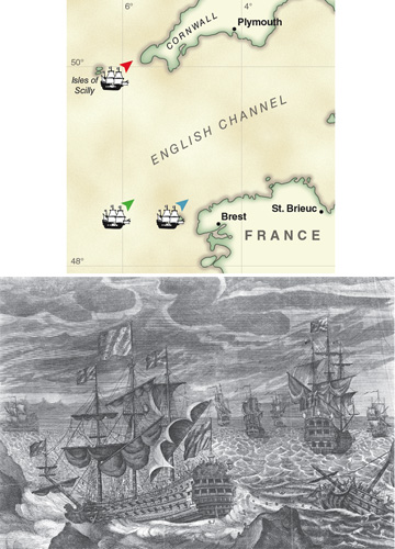
Travel by sea was slow and dangerous during the age of sail. Many ships intending to carry cargo or passengers to distant ports, to wage war or to discover new lands, met disaster at sea and were never heard from again. It was not at all uncommon for coastal vessels simply transporting goods from port to port along the rugged British coastlines to get caught up in fast-moving storms and be driven ashore, at the cost of cargo, ships and lives. But it was extraordinary when, in 1707, a fleet of British naval vessels under the command of Admiral Sir Cloudesley Shovell sailed headlong into the Isles of Scilly off the coast of Cornwall. Having the bodies of hundreds of British seamen, including members of some of the nation’s leading families, wash up on homeland beaches was simply unacceptable. People demanded that an effort be made to prevent such a tragedy from occurring again.
National Maritime Museum, Greenwich, UK./strong>
Shovell and his fleet had sailed from Gibraltar bound for England on or about October 10, 1707. They suffered stormy weather nearly continuously for the next 10 days. They were unable to make reliable astronomic observations and were forced to navigate by dead reckoning, a process that combined compass readings and speed estimates. On October 21, soundings found the water depth to be some 90 fathoms, suggesting that the fleet was nearing land, and the skies cleared enough to permit some astronomic observations. The results were inconsistent but seemed to indicate that the fleet was just offshore of Ushant, France. If that was the case, sailing northeast would carry the fleet safely into the English Channel and Admiral Shovell issued orders to do just that.
Tragically, the fleet was not off Ushant. It was nearly a degree and half to the north and a degree to the west—in the immediate vicinity of the Scilly Islands. The only reasonable explanation for such a large navigational error appears to be that the fleet made more rapid headway than reckoned, either because the current they faced was weaker than normal or because gusty winds resulted in faster sailing speeds than were estimated. Admiral Shovell’s decision to try to make port immediately rather than wait for a more reliable determination of his position was simply foolhardy and cost 2,000 lives, including his own.
Ignoring the fact that the error in latitude in nautical miles had been twice that of the error in longitude, the Admiralty chose not to blame the disaster on the mistake of a highly respected member of the nobility. Instead, it focused on the notoriously difficult problem of accurately determining longitude at sea. In 1714 the British Parliament passed the Longitude Act, which established the Commission for the Discovery of Longitude at Sea, more commonly referred to as the Board of Longitude. The Act provided three prizes based on the accuracy of longitude measurement: £20,000 (equal to more than $3 million today) to anyone who could find a way to determine longitude at sea with an accuracy of one-half degree, £15,000 for two-thirds degree and £10,000 for one degree.
Forming the Board of Longitude to search for a solution to the longitude problem benefitted members of Parliament and the Admiralty. By shifting the longitude problem to the scientific community, they stifled public criticism of their inability to solve the problem. After all, if the leading scientists of the age, including even Isaac Newton, had no solution, what could anyone expect from them? Passage of the Longitude Act also benefitted the scientific community, especially astronomers. By taking on the task of finding a solution, astronomers assured themselves of continuing funding to collect and analyze observations, to travel to distant lands to observe events such as lunar and solar eclipses and to develop new instruments. Members of the Board of Longitude received reimbursement for expenses associated with carrying out their duties and appointment to the body became a coveted honor.
Heritage Images/Corbis
But was it responsible governance to pass the Longitude Act without other efforts to protect British seamen? Or might it have been subterfuge—a disingenuous attempt to shift attention away from the realities of their life at sea. Conditions were horrendous aboard most British naval vessels at the time. Scurvy and other diseases ran rampant, killing more seamen each year than all other causes combined, including combat. Few experts felt that a solution to the longitude problem would be found quickly, so there was little chance that the prize moneys would be paid out for decades. If someone did solve the longitude puzzle, it would have been well worth the prize moneys and not only for the lives saved. Improved navigation would enable British naval vessels to accurately map the shorelines of continents and islands as they sailed the globe. While doing so, Britain could record the precise locations of distant ports belonging to nations such as France and Spain, with whom Great Britain so often found itself at war.
With the approval of the Board of Longitude, astronomers set about collecting the many thousands of observations needed to determine accurately the right ascensions and declinations of bright stars covering the full sky, including the increasingly important southern hemisphere. And they worked to improve their ability to predict the motions of the Moon, the Sun and the planets relative to the background of the stars, which from Earth appear to be unmoving. Being able to accurately predict the ever-changing declinations of the Moon and Sun was particularly valuable for nautical navigation because measuring the altitudes of these bodies near transit (as they crossed the observer’s meridian) was a convenient and accurate way to determine latitude. Little was needed beyond knowing the approximate day of the year. Combining reliable measurements of a ship’s latitude with estimates of its longitude based on dead reckoning helped navigators recognize landmarks as they approached continental coastlines and identify specific islands among others of a group.
Newton had considered the problem of measuring the altitudes of celestial bodies from the deck of a ship at sea as early as 1699 and communicated his ideas for a reflecting quadrant to Edmund Halley. Unfortunately neither Newton nor Halley published the design and it was another three decades before John Hadley independently developed an octant of similar design. Hadley’s octant soon became the standard instrument for celestial navigation at sea before being replaced by the sextant, an instrument of essentially the same design but with a larger range of observable angles—120 degrees rather than 90 degrees. The sextant made determining latitude at sea faster, easier and more accurate. It also made possible the first practical solution to the longitude problem, because it could be used to measure the angular separations, or distances, between celestial bodies—most importantly between the Moon and stars, the planets and Sun, measurements referred to as lunar distances.
Lunar distances were the key to determining longitude at sea without a clock that could carry Greenwich time accurately for months or years while exposed to changes in gravity and temperature and to the continual slap of waves. As seen from Earth, the Moon moves relatively rapidly against the background of fixed stars—approximately 13 degrees per day, or roughly one lunar diameter per hour. By measuring the lunar distances of known stars, planets or the Sun and comparing them to tables of predicted values for Greenwich (corrected for local refraction and parallax), it was possible to accurately compute Greenwich time. A pocket watch could then be used to keep time well enough during the interval required to observe altitudes of one or more celestial bodies in order to determine the difference between Greenwich and local time—that is, the observer’s longitude. However, there was one catch. The motion of the Moon is anything but simple. It is so complex that Isaac Newton is said to have told his contemporary, John Machin, that his head never ached except with his study of the Moon.
Fortunately, in 1753 the German astronomer Tobias Mayer published a new set of highly accurate lunar tables. In 1765, after 11 years of negotiations, the British Parliament awarded Mayer’s heirs £3,000 for use of the tables. Nevil Maskelyne, the fifth Astronomer Royal of England, set about developing step-by-step instructions and ancillary tables. A ship’s captain or navigator, without extensive mathematical skills, could follow the tables to “reduce” raw lunar distance observations and obtain his vessel’s longitude. Maskelyne’s tables became the basis for the Nautical Almanac published in England annually beginning in 1767.
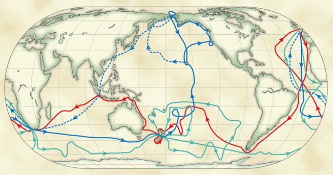
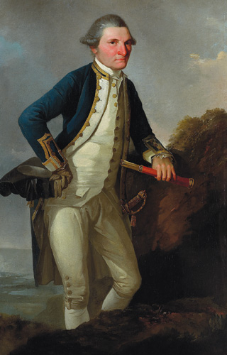
Captain James Cook took along a set of Maskelyne’s tables on his first exploratory voyage to the South Pacific, from 1768 to 1771, on board the HMS Bark Endeavour. Cook and Charles Green, an astronomer aboard the ship as a member of the Transit of Venus observing party, made frequent determinations of the ship’s longitude along the way. Cook reported in his journals that “By these [Maskelyne’s] tables the calculations are rendered short beyond conception and easy to the meanest capacity.”
Cook was exuberant in praising the lunar distance method of determining longitude, saying that it could “never be enough recommended to the attention of all sea officers, who now have no cause left for not making themselves acquainted with this useful and necessary part of their duty. Much credit is also due to the Mathematical Instrument makers for the improvements and accuracy with which they make their Instruments for without good Instruments the Tables would loose [ sic ] part of their use.” Still, the measurement of lunar distances required more skill than the simpler measurements of the altitudes of celestial bodies, usually requiring anchoring in a well-sheltered harbor or going ashore to collect the necessary observations.
On his second voyage of exploration, from 1772 to 1775, Cook took four sea clocks aboard the Resolution. The primary clock was a copy of John Harrison’s clock H4 (which had performed well in sea tests conducted in 1763), made by Larcom Kendall, and designated K1. The other three clocks were of different design and made by John Arnold. Cook reported that one of Arnold’s clocks “kept time in such a manner as not to be complained on.” However, he was much more enthusiastic about K1, stating that “it had been found to answer beyond all expectation.” Cook was particularly pleased to have a clock that kept time well enough to determine longitude accurately from simple altitude observations, which could be accurately performed at sea. In his journal he noted that “Even the situation [latitude and longitude] of such islands as we past [sic] without touching at are by means of Mr. Kendall’s Watch determined with almost equal accuracy.”
Confident that he could determine his position generally to within a few minutes of arc, Cook could devote less time to finding his way. He could give more attention to surviving wind and ice storms, avoiding being driven onto leeward shorelines and reaching protected areas of anchorage. His journals contain entry after entry about his decisions to skip anchorage spots completely or to spend days waiting for the right combination of wind, tides and currents to enter sheltered bays, and the mouths of rivers to resupply with fresh food, water and wood. He was often forced to resort to towing his ship with rowboats, or hauling anchors out, placing them and then “warping” his ship to an anchorage by pulling in the anchor lines. It would have been so much quicker and safer if he had had a self-contained, on-demand source of propulsion, the simplest mechanical engine, rather than only the capricious wind.
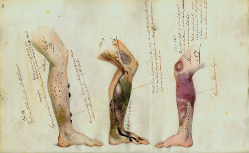
It is impossible to determine with any certainty how many lives were saved by the advances in navigation that can be fairly attributed to passage of the Longitude Act. But if Parliament and the Admiralty had truly been focused first and foremost on saving the lives of common British seamen, they would logically have offered prize moneys to solve pressing problems besides the accurate determination of longitude at sea. Their ships desperately needed a better method of propulsion, and their captains needed practical methods to stop the suffering and death of seamen to scurvy. During the Seven Years’ War (1756–1763) alone, it is estimated that some two-thirds of the more than 180,000 seamen conscripted into the British navy died of disease, mostly scurvy. On his own initiative, Cook implemented dietary and hygienic measures—including feeding his men greens harvested at ports during their journey—that virtually eliminated scurvy on his ships. But seemingly without concern for loss of seamen, the Admiralty continued to encourage captains who did not take these measures to sail their ships into the highly dangerous Arctic waters in search of a northwest passage from England to the Far East, a region with enormous trade potential. The Admiralty even extended the £20,000 prize they established in 1731 to their naval ships.
Gift of the New Zealand Government, 1960/The Bridgeman Art Library International
It was not until the Royal Society of London awarded Cook the prestigious Copley Medal in 1776 for his contribution to preventing scurvy that the Admiralty was forced to address the problem. Sir John Pringle, president of the Royal Society, in presenting the award stated that “Britain may now, on the most distant voyages preserve members of her intrepid sons, her mariners; who, braving every danger, have so liberally contributed to the fame, to the opulence, and to the Maritime Empire of this country.”
Cook’s voyages were widely proclaimed to be purely journeys of discovery, of great scientific value to all nations. His discoveries of new lands and the creation of accurate maps and charts did contribute profoundly to understanding of the world’s remote regions. Both France and the United States provided Cook’s ships safe passage, even while their nations were at war with Great Britain. But Cook actually sailed under secret orders, alluded to in his journals but not discovered and published by the Navy Records Society until 1928. These orders directed him to search for a large continent believed to exist in the southern Pacific Ocean and, with the consent of natives, to take possession of it for the king of Great Britain. He was also ordered to claim for the monarch any other lands he discovered that were not already appropriated by European nations. Failure to disclose these orders constituted a certain act of subterfuge by the Admiralty, forever tainting the remarkable discoveries of Captain James Cook.
Click "American Scientist" to access home page
American Scientist Comments and Discussion
To discuss our articles or comment on them, please share them and tag American Scientist on social media platforms. Here are links to our profiles on Twitter, Facebook, and LinkedIn.
If we re-share your post, we will moderate comments/discussion following our comments policy.