The Pump Don't Work
By David Schoonmaker
"Water, water, every where, Nor any drop to drink."—Samuel Taylor Coleridge
"Water, water, every where, Nor any drop to drink."—Samuel Taylor Coleridge

DOI: 10.1511/2007.66.315
Most of us are accustomed to associating drinking-water problems with arid regions, such as the United States’ desert Southwest, where quantity is the primary concern. Sometimes, though, we can get thirsty in the midst of plenty.
Coastal Georgia and southeastern South Carolina sit above a spectacular source of drinking water, the Upper Floridan Aquifer. More than 80 percent of the residents there depend on it. Indeed, Savannah, Georgia, and Hilton Head Island, South Carolina, collectively pump about 80 million gallons of water from the Upper Floridan each day. Yet despite those ambitious withdrawals, the aquifer faces no imminent risk of depletion. The threat is more complicated than that.
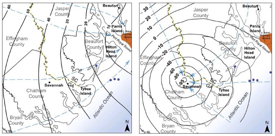
From Falls et al. USGS 2005-5134; left elevations from Krause and Randolph USGS 1989-1403D, right from Garza and Krause USGS 1996-2411.
The Upper Floridan extends not only below land areas but also below coastal salt marsh, tidal rivers and even well out into the Atlantic Ocean. Its top varies from perhaps 60 feet to a few hundred feet below the surface. A layer of Miocene Epoch rock confines the top of the aquifer and protects it from intrusion by saltwater from above. Even 20 years ago, most of this information would have come as news to geologists, but of late knowing such details has taken on a certain urgency.
As recently as the late 19th century, drilling a well into the Upper Floridan near Savannah resulted in freshwater gushing up with a pressure equivalent to a “head” of +30 feet. No more. The pumping of water for residential, industrial and agricultural uses has depressed the head below mean sea level over a 2,350-square-mile area. At Hilton Head, it’s about –10 feet, whereas at Savannah it approaches –100 feet. The differential creates the potential for saltwater from above to be pulled downward into the aquifer.
Naturally, the most significant risk for intrusion happens where the pressure differential is greatest and the confining layer thinnest. Fortunately, the latter is a relatively robust 50–200 feet thick near the tip of the cone of depression in the Savannah area. But there are places where it is much thinner. Ancient rivers eroded the Miocene layer during times of lower sea level. Known paleochannels exist in Port Royal and Calibogue sounds and near Tybee Island in the ancestral Savannah River channel, which ate away 40 feet of the 60-foot-thick aquitard, as geologists call it.
Numerous investigations conducted over the 50 years prior to 2005 had not found evidence of large intrusions of saltwater into the aquifer, leading the Georgia Environmental Protection Division, which had been closely monitoring these studies, to conclude that restricting withdrawals to 1997 levels should be sufficient and that some additional withdrawal might even be possible. But before any action could be taken, new work put the kibosh on the notion.
Camille Ransom, III, a hydrogeologist with the South Carolina Department of Health and Environmental Control (SCDHEC), has been monitoring wells in the southeast corner of South Carolina for 30 years, and in 2005, he, James Landmeyer with the U.S. Geological Survey, and Robert Logan and Jack Childress, both also with SCDHEC, took detailed core samples at two critical locations overlain by saltwater. Using an on-site press that exerts 2,000 pounds per square inch of pressure, they extracted pore water from the core every five feet in the confining layer and analyzed the samples for chloride. “Looking at a sample, you would be amazed there’s any water in it at all,” says Ransom. But water there is—and salt too.
They then used these samples to calibrate a model that estimates saltwater seepage in a grid of four-square-mile cells covering the 1,200 square miles of area with below-sea-level head that’s also overlain by saltwater. “It’s not that no one ever considered that seepage might be a concern. Five studies were done before ours, but they were limited in scope,” says Ransom. No one had previously tried to calibrate a model to estimate the volume of seepage over a regional area.
The clayey Miocene rock is actually about two-thirds sand and only “relatively” impermeable. The team’s work shows, as expected, a downward gradient of salinity through the confining layer, but chloride concentrations at the top of the Upper Floridan may be well above background levels.
Ransom and his colleagues estimate that the downward seepage of water into the aquifer is probably comparable in volume to the amount of water entering laterally. The team’s model suggests that an area of concern encompassing 382 square miles will reach chloride levels of 500 milligrams per liter at the top of the aquifer in -25 to 113 years. Negative numbers mean that the level has already been reached, and on average that level will be reached in 2041. The U.S. Environmental Protection Agency sets a maximum limit of 250 milligrams of chloride per liter for secondary drinking water. Altogether, Ransom and his colleagues estimate that 7.6 million gallons of water, some of it abnormally salty, are entering the Upper Floridan each day from seepage alone.
There are no simple solutions. Camille says that “to reverse the problem, pumping would have to be reduced much more than is likely to be practical any time soon.” But he does say that peak pumping levels are down somewhat, owing to reductions in industrial use in the Savannah area and replacement sources.
Hilton Head Island buys water from nearby Beaufort and Jasper County. It also mixes captured runoff and Middle Floridan water for irrigating golf courses and has built a 4-million-gallon-per-day reverse-osmosis plant that treats water from a 3,800-foot well into the Middendorf and Cape Fear aquifers. These measures have allowed Hilton Head to reduce its withdrawals from a peak of 14.7 million gallons per day to 9.7 million. Surface sources, such as the Savannah River are also possibilities, but treating that water will be more expensive than pumping the once-pristine Upper Floridan. Yet another metaphorical albatross has been slain.
Click "American Scientist" to access home page
American Scientist Comments and Discussion
To discuss our articles or comment on them, please share them and tag American Scientist on social media platforms. Here are links to our profiles on Twitter, Facebook, and LinkedIn.
If we re-share your post, we will moderate comments/discussion following our comments policy.