Connecting Habitats to Prevent Species Extinctions
By Stuart L. Pimm, Clinton N. Jenkins
Conservation biologists are creating links between forest fragments where the most animals with small ranges live.
Conservation biologists are creating links between forest fragments where the most animals with small ranges live.
By the time Charles Darwin landed in Brazil in 1832 while on his voyage on the HMS Beagle, Europeans had known for centuries that the tropics house an extraordinary variety of strange, exotic species.
Darwin wrote gushing letters to his family about the birds, butterflies, flowers, and other thrilling organisms he saw. From reading travelers’ accounts, he had expected the richness of the flora and fauna. Yet he missed something vitally important that was unknown at the time: Many species are unique to the coastal region of Brazil, and some are found only on a few mountaintops. Later, Darwin’s realization that there are special places where many species with small geographical ranges are concentrated would change science.
Edward Parker/Alamy Stock Photo
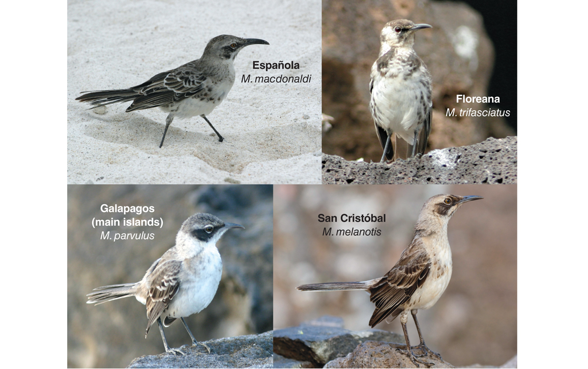
What Darwin didn’t know is something profound about the sizes of the geographical ranges of species. It seems such an esoteric fact: He was unaware that many species have tiny geographical ranges. So when he visited the Galápagos Islands in 1835, the presence of four clearly different, but related, species of mockingbird on such small islands came as a profound shock. “The fact, that islands in sight of each other, should thus possess peculiar species, would be scarcely credible,” he wrote, “if it were not supported by some others of an analogous nature.” Nothing in his experiences of England’s natural history had prepared him for this discovery. The taxonomist and illustrator John Gould confirmed the distinctness of the mockingbird species with his descriptions of them in 1837. Just how singular they were was novel to him, too. Worldwide, only six known species had smaller geographical ranges—and none of them formed a cluster of species in the same genus. It would take decades for scientists to realize that some special parts of the tropics had many species with small geographical ranges.
Alfred Russel Wallace set out for the Amazon the next decade. Yet it was not there, but in insular southeast Asia that he made his observations on small-ranged species that he published in his “Sarawak Law” paper of 1855, which set the clock ticking on the famous pair of papers announcing the theory of evolution. Like Darwin, he marveled that islands so close to each other could have different, but related, species.
Stuart Pimm, et al.
In the century that followed, there would be massive destruction of these special forests where small-ranged species were concentrated. Only in the past few decades have scientists understood that this destruction, combined with the uniqueness of the species in these areas, poses one of the greatest challenges to conservation. Such places typify the frontlines of the fight to reduce global rates of species extinction, which are now 1,000 times their normal rates, according to a 1995 study in Science coauthored by one of us (Pimm).
The salient feature of biodiversity in the 21st century is that the places that inspired Darwin and Wallace to think about the origins of species are now where species are dying. To find out what we can do to prevent extinctions, we must first understand where species are, which ones are vulnerable and why, and where they live.
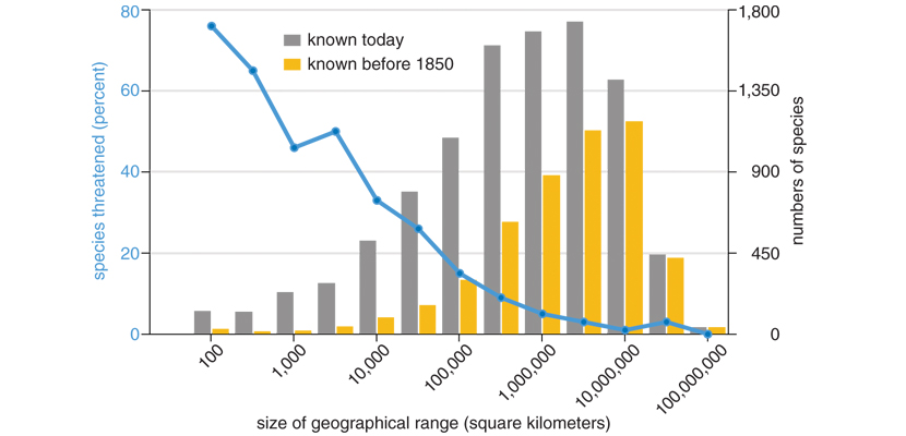
Small-ranged species are disproportionately at risk of extinction. The “Red List” of the International Union for the Conservation of Nature (IUCN) aspires to assess the risks of extinction of all species. It has done so for more than 90,000 plant and animal species, out of a total of nearly 2 million species that taxonomists have described. Birds, mammals, and amphibians are the best known. Overwhelmingly, it’s the species with small geographical ranges that are at greatest risk. For birds, the risk of extinction drops dramatically as range size increases. About half the species with ranges smaller than 1,000 square kilometers are at risk.
This pattern is not surprising. Other things being equal, the destruction of habitats is more likely to terminate a species that occurs, for instance, on a few mountaintops in coastal Brazil, than one that occurs across the entire Amazon basin. The challenge for conservation science is what we can do to protect these threatened species.
We now know that species with small geographical ranges, which are so often threatened, are concentrated in certain places. And in these mostly tropical concentrations, human actions not only destroy habitats but also leave what’s behind in small, isolated fragments. These patches may be too small to sustain viable populations of species. Restoring corridors—habitat connections between fragments—affords a cost-effective solution. For the past decade, we have worked with local partners and started corridor projects in Brazil, Colombia, Ecuador, India, and the Indonesian island of Sumatra.
Many more species with small geographical ranges are known now than in Darwin and Wallace’s time. By 1850, taxonomists had described close to 5,000 terrestrial bird species in the world. The histogram above shows the numbers of bird species in each category of range size. In 1850, 14 years after Darwin returned from his voyage, only 200 (4 percent) of the known species at that time had ranges smaller than 10,000 square kilometers. Today, that number is 1,290—close to 13 percent of the more than 10,000 species now known.
Stuart Pimm/Dušan Brinkhuizen
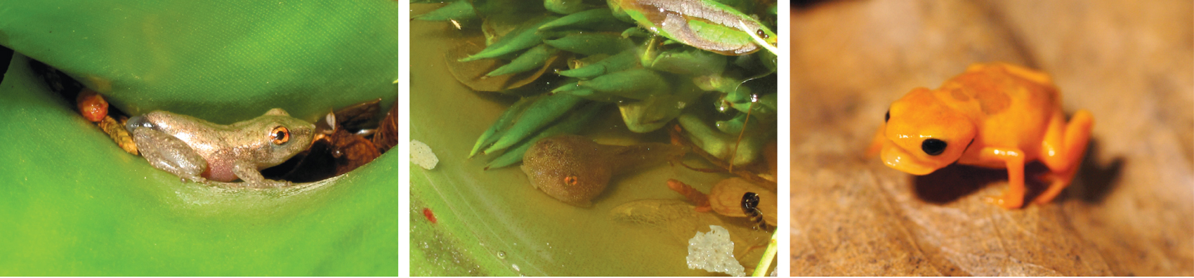
We’re still finding more such species. In a paper we published in 2010 about Brazil, we showed that taxonomists have described half of the known amphibian and mammalian species with small ranges in the past few decades. Many more are surely awaiting discovery. As with birds, large-ranged species were discovered earlier than small-ranged ones.
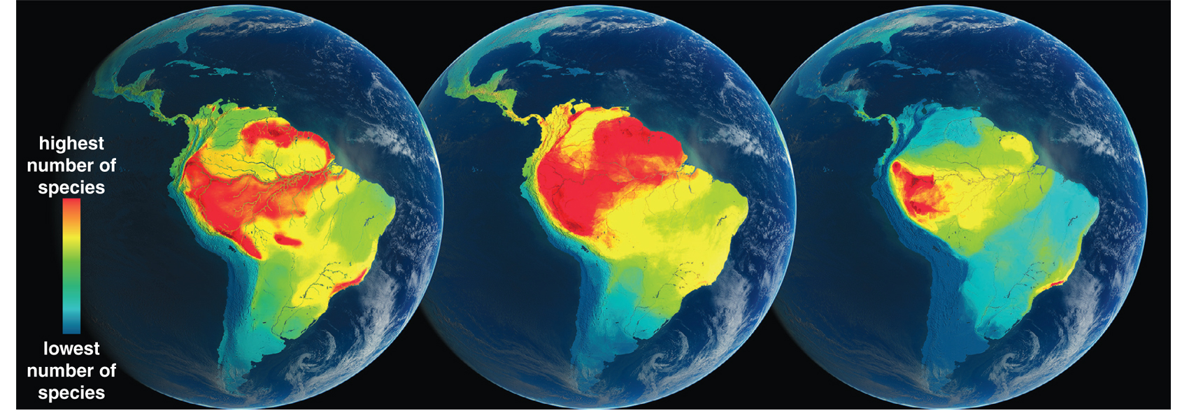
The century and a half of exploration since the travels of Darwin and Wallace has made it possible to produce three key maps that show the areas that have, respectively, the greatest numbers of species, the greatest numbers of species with small ranges, and the greatest numbers of species that are threatened with extinction. Geography is destiny. Understanding the relationships between these geographical patterns is the first vital step in determining where to act to save species.
Humans have disproportionately harmed those places where small-ranged species are concentrated.
Likely, the maps below would not have surprised Darwin and Wallace. The greatest numbers of species in a given place are in the tropical moist forests of the world. The patterns are broadly similar for birds, mammals, and amphibians—the taxa we know best. Less geographically resolved data for insects and plants suggest the patterns are also broadly similar. Wallace went to the Amazon because that’s where the most species are! He made his living collecting novelties—species other collectors had not discovered. He likely thought that more species would mean more novelties—but he was partly wrong, as the next map shows.
Globaïa
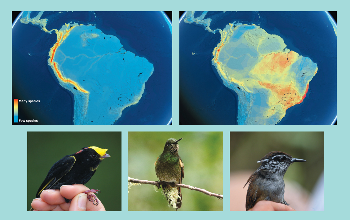
The map on the left below shows where the half of all bird species that have the smallest ranges occur. It contains fully half of the species as the left-hand map above, yet it is profoundly different. Small-ranged species in the Americas are concentrated in Central America, along the Andes, and in a strip of forest along the Brazilian coast. (Exactly why small-ranged species are concentrated in moist, tropical mountains is a matter of some debate.)
Stuart Pimm
Neither Darwin nor Wallace could have had any sense of this map, because species with small ranges were only just coming into European museums when the two men were traveling. (And it took many more decades to understand their complete geographical ranges.) Wallace didn’t go back to the Amazon; his next trip was to islands in southeast Asia where there were concentrations of small-ranged species. The novelties there were what made him famous.
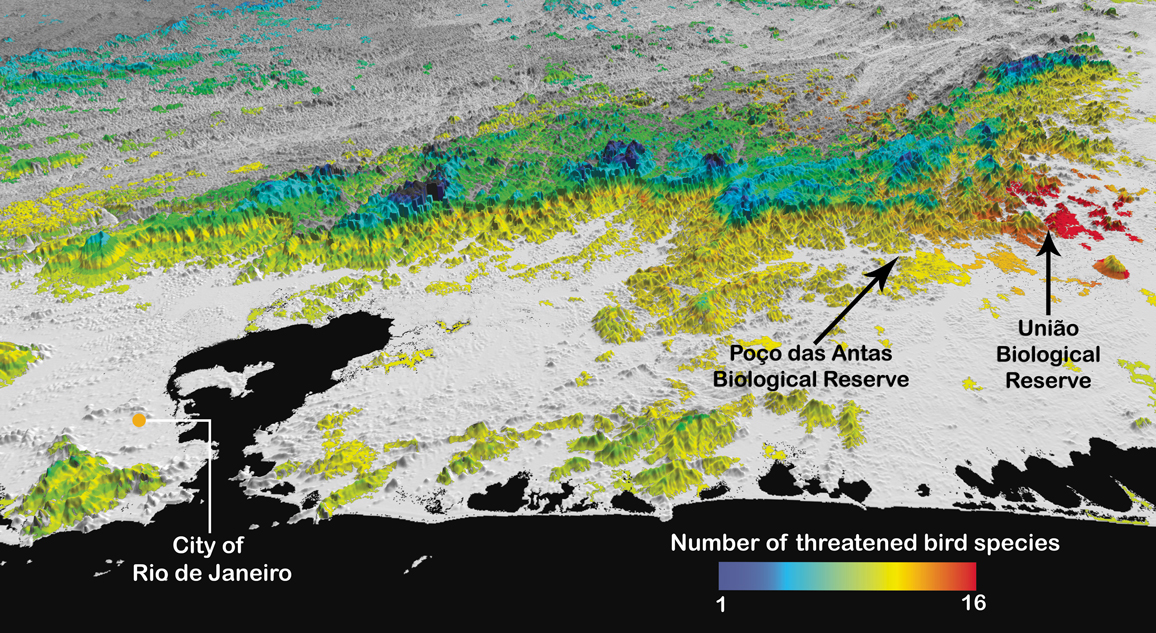
The above map on the right shows the numbers of threatened bird species in Central and South America. Small range makes a species vulnerable, but the extent of habitat destruction matters too. Higher concentrations of small-ranged birds occur in the Andes than in coastal Brazil, but a greater number of threatened species is found in Brazil, because habitat destruction has been greater there.
The environmentalist Norman Myers coined the term biodiversity hotspots for these places where concentrations of small-ranged species have collided with extensive habitat loss. His influential insight was that human actions are exceptionally damaging. For various reasons, we have disproportionately harmed those places where small-ranged species are concentrated. Maps provide high-resolution improvements on his groundbreaking ideas. More maps are on the website www.biodiversitymapping.org, including maps of marine species that show patterns broadly comparable to what we see on land.
The common perception is that threatened species are large or fierce animals. The website for the World Wildlife Fund lists giant pandas, tigers, elephants, gorillas, sea turtles, polar bears, rhinoceroses, and whales as its species of concern. Almost all these creatures have large geographical ranges. Human actions threaten these and similar species despite that fact. In addition to destroying their habitats, we hunt them for food; for ivory, horn, or bones; for pets; or because they come into conflict with humans.
Understandably, these charismatic species command our attention, while the majority of threatened species do not. Their survival requires solutions that include suppressing poaching, reducing demand for animal products, and reducing human-wildlife conflict. Here, we will focus on the nine-tenths of threatened species for which the destruction of natural habitats is the main threat to survival—the organisms found in the places colored orange and red on the above map on the right.
The distinction is not absolute. Giant pandas are iconic, and the Chinese government has invested considerable efforts into expanding the areas that protect them. Fortuitously, giant pandas live in the mountains of southwest China; like the northern Andes, this region houses concentrations of small-ranged organisms. One of us (Pimm) and our colleague B. V. Li showed that many other threatened species of plants and animals live under the panda’s protective umbrella.
Coastal Brazil has a high concentration not only of threatened bird species, but also of threatened plants, mammals, and amphibians—and likely other species as well. This concentration reflects the collision of the high number of species with small geographical ranges that live there and the area’s massive deforestation. Looking more closely, we see that areas within the state of Rio de Janeiro have the highest concentrations of all.
Even more detailed maps are essential to identify where to act and how. The challenge now is to scale down from these large-scale, strategic maps covering many millions of square kilometers to maps that allow tactical interventions, ones that typically involve areas no larger than a few square kilometers—a reflection of the extent to which human activities have destroyed so much of the natural landscape.
To do so, we consider individual species maps in turn. These maps are like those one finds in field guides—they provide a boundary within which a species is likely to occur. Each species probably does not occur everywhere within that boundary, however. First, species have elevational limits, and in mountainous places such as this one, some of the area will not be at the right elevation.
© 1996, CCC Republication
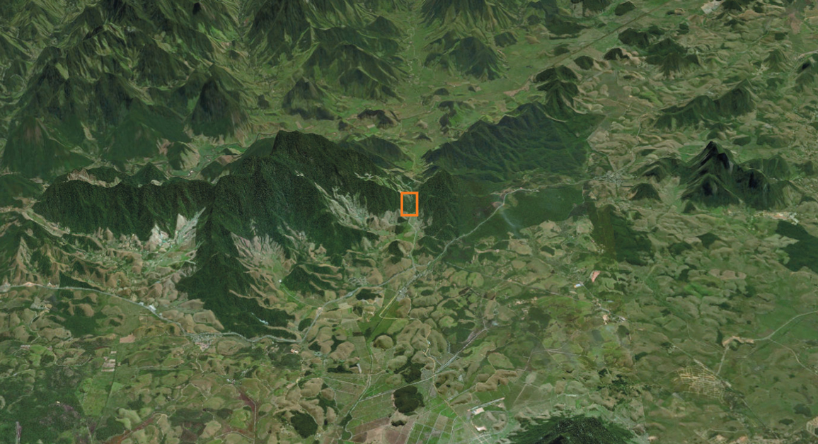
Second, species need specific habitat. Most of the species in this area of the state of Rio de Janeiro, shown above, live in forest and so have lost much of their habitat. We trim each species range by elevational range and by remaining forest habitat, and then we combine these maps to summarize the areas of greatest conservation interest.
The map above shows the result. Only areas that have forest are colored. The colors drape over a three-dimensional rendering of the topography and show the numbers of threatened species expected to be found. The greatest numbers of threatened species are in lowland forest fragments to the east, an area we show in greater detail below. What is striking is the degree to which the remaining forest is in fragments. Quite generally, satellite images show that within the mostly tropical concentrations of threatened species, human actions can destroy or damage habitats, leaving behind only small, isolated fragments. These patches may be too small to sustain viable populations of species. Once we appreciate the risks posed by fragmented ecosystems, we can begin to understand what’s going wrong and how to address it.
ArcGIS Pro
In their classic 1967 book The Theory of Island Biogeography, ecologists Robert MacArthur and Edward O. Wilson noted that small islands have fewer species on them than large ones, as do those more isolated from the mainland than those nearby. From the outset, they extended their ideas to habitat “islands”: typically forest fragments surrounded by a “sea” of unsuitable habitat, often farmland or pastures. When human action turns large regions into these de facto islands, diversity declines.
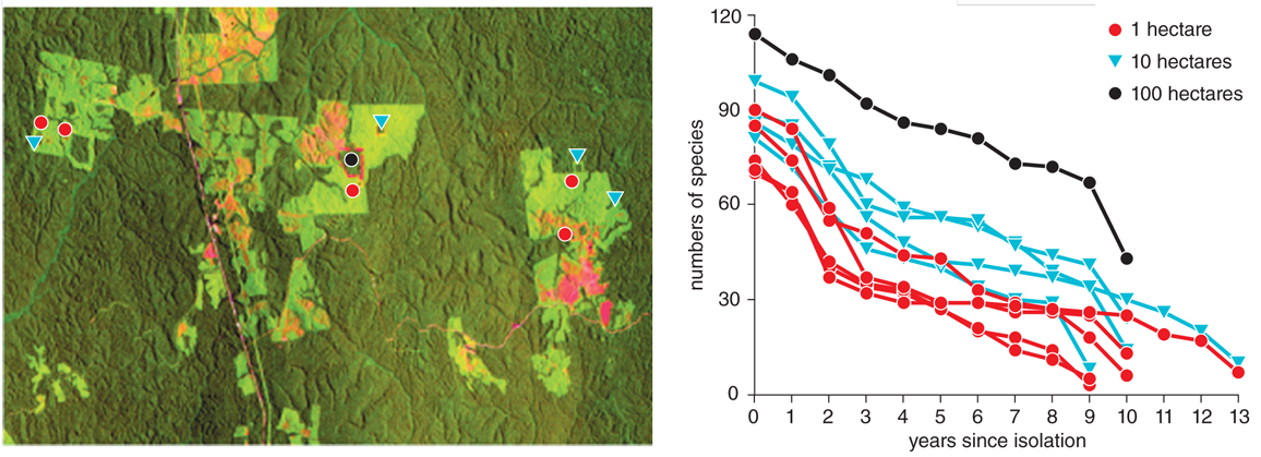
We know in detail what happens to species in fragments from what was surely the longest, largest-scale ecological experiment ever planned: the Biological Dynamics of Forest Fragments Project. This project, envisioned by the ecologist Thomas Lovejoy 40 years ago, arose from his knowledge that ranchers were about to clear an area of continuous Amazon forest for cattle ranching. By law, a fraction of the land had to remain forested. Before they cleared the forest, Lovejoy was able to establish a series of forest patches of 1, 10, and 100 hectares, and a nearby one of 10,000 hectares.
This experiment is the most direct study of species loss from forest fragments; it started before the areas were isolated and followed their fate annually. The left image below shows a satellite image of the area, just north of Manaus, with the individual fragments identified. The graph to the right of that image shows that annual counts of bird species from before the forests were isolated (year 0) were higher in the larger fragments than in the smaller ones. Over time, larger fragments also lost species more slowly.
Springer Nature; Stuart Pimm et al.
Other studies have taken a more indirect approach to studying conservation and habitat fragments. Studies from lakes flooded by reservoirs can yield data for years or decades after islands form within them. By extension, islands formed tens to hundreds of thousands of years ago by sea-level rise provide comparable numbers over greater temporal and spatial scales.
Very roughly, a fragment must be at least 1,000 hectares to slow the time it takes to lose half the species to a century or more. That result is actionable science. It provides a prescription for how to slow the rate of extinction: We must reconnect the habitat fragments and make them large enough for their species to persist in the long term.
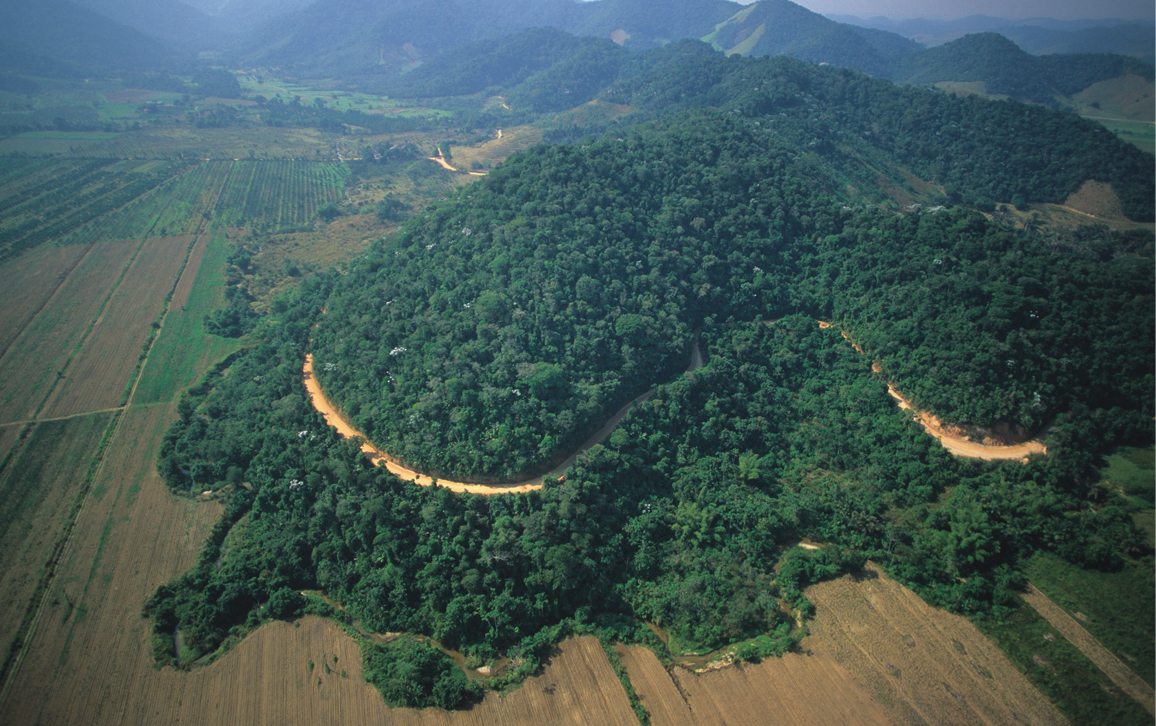
Connecting isolated forest fragments is the inspiration behind the work of a nonprofit that we direct. Coastal Brazil provides two examples of what we do. The aerial image above shows an area about 100 kilometers east of the city of Rio de Janeiro. It’s typical of the other sites across the world’s tropics where we work. It illustrates our practical solutions to preventing extinctions and has global applicability.
The Brazilian landscape is a mix of native forests—mostly on hilltops—and cropland and settlements. The contrast between the forest and the open lands is striking—the latter is hot, dry, and dusty, whereas the forest is warm, humid, and full of the plants and insects that so fascinated Darwin in 1832.
The area at the center right of that aerial image is a federally protected reserve, Reserva Biológica União, to which the public has limited access along trails. Swallow-tailed hummingbirds and violet-capped woodnymphs feed on the flowers, flocks of red-rumped caciques call noisily, and in the canopy there are mixed-species flocks of tanagers, as well as brightly and variedly colored fruit eaters. Large Morpho butterflies flit along the trails, flashing iridescent blue as they catch the sunlight.
We knew from our maps that this reserve could also be home to many rare species at risk of extinction. And we knew it held a population of an engaging little monkey called the golden lion tamarin. This species has a small geographical range; it is endangered because much of its forest habitat has been lost to croplands, roads, and towns. (In the early 1990s, its range was about 100 square kilometers.)
Felipe Toledo
From what we know about fragments, we knew that the major problem for this species—and for other species restricted to these forests—was that its range was limited to a few small reserves like this one. So, they were at high risk. The reserve of about 2,500 hectares was isolated from the forest to the west by a strip of cattle pasture.
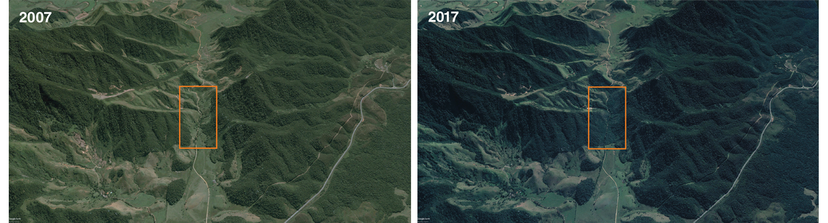
We worked with a Brazilian nonprofit partner, the Associação Mico-Leão-Dourado (the Golden Lion Tamarin Association), to buy the land to create a habitat corridor between the forest to the west and the reserve, indicated by the right-hand arrow on the previous map around Rio. Starting in 2008, restoration work by the association filled in the gap with forests. The satellite images below show the gap before the corridor was established (2007) and what it looked like recently (2017). With that restoration, key species, including the golden lion tamarin, are now moving through the corridor this project has restored. Deforestation had almost driven the tamarin to extinction, but energetic and creative conservation has increased the numbers steadily. Projects like this have given them the chance to find new homes.
Google Earth/Landsat/Compernicus/image © 2019 DigitalGlobe
The project had a political success, too. After buying the corridor, the Associação turned the land over to the Brazilian government agency responsible for protected nature areas. Recently, they expanded the Reserva Biológica União to include not only the corridor lands but also forests to the west, to create a reserve of nearly 8,000 hectares. We know that reserves of this size can maintain viable populations of many of their species in the long term, and this example is vital for inspiring international actions.
There’s another important lesson too. This corridor includes uplands to which species can move. As the climate warms, species are moving to higher latitudes and, in the tropics, to higher elevations—that is, if they can. The habitat around fragments is often hostile, and species—even birds—generally do not cross it. An isolated fragment is bad because it may not be large enough to support a viable population and worse because it prevents species from reaching safe harbors at higher elevations.
So, with the Associação Mico-Leão-Dourado, we knew we could build corridors. But the challenges to connecting the Reserva Biológica Poço das Antas, indicated by the left-hand arrow on the previous map of the area around Rio, were far more formidable. This lowland forest reserve is isolated, too. It also contains populations of endangered species, including the lion tamarin. To connect it to forests to the north (and at higher elevations) requires the purchase of a farm, forest restoration of its pasture land, and, most difficult of all, the building of a habitat bridge across one of Brazil’s major highways. (The reserve is on the south side of the highway.) Work on this project started in mid-2018.
More generally, armed with the information about the relationship between fragment size and species loss rates that the earlier graph shows, we can ask by how much the rate of species extinction could be slowed by reconnecting isolated forest fragments through the restoration to forest of degraded land between them. In work led by our colleague William Newmark, we considered restoring a corridor 1-kilometer wide between various forest patches in Brazil’s Atlantic Forest, as well as in the Eastern Arc mountains of Tanzania—another area of exceptional biodiversity. Our research showed that corridors would provide one of the highest returns on investment for biodiversity conservation worldwide—essentially for the reasons shown by the example of Reserva Biológica União. One can create landscapes that massively slow the loss of species through the connection, protection, and restoration of key corridors without having to purchase large areas.
Efforts to prevent extinctions will be more effective if we continue to collect information in three areas. First, we still need more information about what species are where. We are making strategic decisions on where to protect biodiversity based on a small sample of species—the roughly 20,000 known species of birds, mammals, and amphibians. We have no other choice. Almost all the examples thus far have involved birds. We know a far greater fraction of the species in this group than in mammals and amphibians. For those groups, many more new species are still discovered each year. Although we can map out the ranges of the amphibians and mammals—and can see that their concentrations of threatened species are in broadly the same places as for birds—we are much less certain about the details.
For plants, our work estimates that about another 15 percent of species are still unknown. They are likely to be in the places where small-ranged vertebrates are concentrated and so may also be threatened. But we cannot map out plants in any detail, and the IUCN Red List has assessed very few species to see which ones are threatened. About insects, we know even less (see Perspective, "No Simple Answers for Insect Conservation").
What’s particularly worrying is that we know that the species taxonomists describe first are those with the largest geographical ranges, which are the least likely to be at risk of extinction. That means that what we don’t know are the species with small ranges. Those are the ones that might become extinct before we ever know them.
Clearly, we need to know more about where a wide variety of species occur. Crowd-sourcing applications such as iNaturalist (www.inaturalist.org) are certainly bringing that future closer, however. Since its founding a decade ago, iNaturalist has accumulated more than 16 million observations, many of species that aren’t well-known. Nonetheless, we are decades away from being able to map any groups besides vertebrate species with the accuracy needed to set detailed conservation priorities.
All we can say is that the broad patterns of where small-ranged species occur and where they collide with massive loss of habitat seem broadly the same for the three vertebrate taxa and for flowering plants. A guiding principle seems to be that tropical mountains and tropical islands produce many unique species, and there is good science for thinking this trend applies to many different taxonomic groups.
Second, consider the science of fragments. There are many studies that look at the number of species in differently sized areas of habitat. The rates of loss are broadly similar to those shown for birds in the earlier graph. Small, isolated fragments of habitat are bad news for almost all species. Conservation science has elucidated the details, too: Small populations go extinct because they become inbred or suffer the vagaries of births and deaths and fluctuations in sex ratios. What we need to understand better is how the rates of species losses vary across different taxonomic groups.
Third, ever-better satellite imagery and, more recently, the use of drones to take high-resolution images have enabled a much more detailed understanding of landscapes. These new technologies reveal critical insights about the nature of habitat destruction in biodiversity hotspots.
In the past decade, we have worked with local partners and started corridor projects across the tropics, all in places of exceptional biodiversity. In all of them, what habitats remain are in fragments. As in coastal Brazil, typically some natural habitats remain, usually on hilltops or steep slopes, while lowland areas are cleared for grazing. The methods we document here are widely applicable.
Habitat destruction has dealt the world’s species a bad hand of cards. The areas with the most vulnerable species—the biodiversity hotspots—suffer disproportionate losses of habitats. That said, we still play that game as best we can by using the science of conservation to ensure that our actions are as cost-effective as they can be while being effective for the species that we know and those we have yet to discover.
A forest now grows where a cattle pasture once isolated Reserva Biológica União from the forests to its west, effectively imprisoning the tamarins and many other species. Our field studies show that many species move through that corridor. There’s a great personal satisfaction in healing the scars human actions have carved into the fabric of nature, all the while ensuring that our actions are guided by decades of science.
Click "American Scientist" to access home page

American Scientist Comments and Discussion
To discuss our articles or comment on them, please share them and tag American Scientist on social media platforms. Here are links to our profiles on Twitter, Facebook, and LinkedIn.
If we re-share your post, we will moderate comments/discussion following our comments policy.