Sea Change
By David Schneider
Reflection seismology, a tool of geologists, proves useful to oceanographers
Reflection seismology, a tool of geologists, proves useful to oceanographers

DOI: 10.1511/2004.48.0
Oceanographers charting the sea's ever-changing configuration of water masses struggle with a fundamental problem: The traditional method—lowering instruments into the briny depths and recording the temperature and salinity at various levels—is inordinately time-consuming. Indeed, the features of interest often evolve faster than they can be tracked in this way. But oceanographers might soon be able to obtain better snapshots of the water's internal structure with a novel approach: seismic surveying, a technique used routinely to map geologic strata beneath the ocean floor.
Marine geologists have for decades exploited this tactic, which involves recording the acoustic echoes that bounce back from the various buried layers after a loud blast is set off near the surface. The primary application of such reflection seismology is exploring for offshore oil and gas deposits, but academic scientists also use the method for various geological studies.
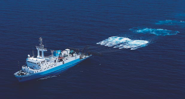
One such scholarly investigation was carried out in 2000 using the Columbia University research vessel Maurice Ewing, near the Grand Banks off Newfoundland. The chief scientist on board was W. Steven Holbrook, a geophysicist at the University of Wyoming. During this particular survey, Holbrook noticed something curious on a monitor being used to check the quality of the data being collected: "There were reflections coming back where they shouldn't have been," he recalls, referring to the echoes he saw emanating not from the seafloor or the buried layers below but from within the water itself.
Holbrook, being busy enough with his geological studies, relegated this observation to his "crazy ideas file." But after he observed the same phenomenon two years later during another seismic survey on the Ewing, he assigned Pedro Páramo, a graduate student in his group, the task of processing the data to accentuate reflections coming from the body of the ocean itself. "Within a few days he had the first water-column image," Holbrook says, adding, "I just about fell off my chair: There were these spectacular structures in that data."
At that point Holbrook decided he had better consult with an oceanographer. His university did not, however, employ anyone in that capacity. (Oceanography is not a popular area of study in Wyoming.) So Holbrook sent some feelers to Woods Hole Oceanographic Institution, where he had once worked, hoping that a little name recognition might help him to be taken seriously. It did. Raymond W. Schmitt, a physical oceanographer there, was quite impressed with what could be seen in Holbrook's seismic-reflection profiles of the sea near the Grand Banks (an area of much oceanographic interest).
Schmitt immediately saw the advantages of probing the ocean in this way. Instead of tediously trying to survey the sea by lowering and raising oceanographic instruments on a cable—a tactic that limits a ship's speed to about a knot—oceanographers like himself could image a two-dimensional slice of the ocean by towing the appropriate seismic equipment behind the survey ship, which can then travel at several knots' clip. That gives almost an order-of-magnitude reduction in the time needed to perform a survey, which, in Schmitt's words, constitutes "a remarkable quantum leap."
Holbrook and Schmitt collaborated in further checking the seismic results and interpreting their oceanographic significance, eventually publishing (with Páramo and Scott Pearse, another Wyoming graduate student) a paper in Science. In the course of preparing that article, Holbrook discovered two earlier efforts to use seismic-reflection data to map goings-on within the ocean. Joseph D. Phillips, for one, had published on this topic in 1991, when he was at the University of Texas at Austin. Phillips, who is now retired, says that the use of reflection seismology to image the ocean has a long history, in fact, but not one that many people know about. This early work was done in support of a Cold War–era Navy program called SOSUS (for SOund SUrveillance System), which took advantage of a relatively deep layer within the ocean that tends to trap the sound energy coming from ships and submarines. So, as Phillips explains, "much of that work was classified."
Holbrook's Science paper brought this promising method out of the shadows last year. Perhaps soon oceanographers will be competing with geologists for funding to carry out marine seismic-reflection surveys. But even before that eventuality comes to pass, oceanographers will want to take advantage of the vast archive of seismic-reflection data already obtained. Getting hold of the appropriate data sets might, however, present a challenge, even for public-domain results collected in the course of academic studies. Tom Shipley, a geophysicist the University of Texas at Austin, notes that because the academic institutions that acquired these data originally had limited resources for archiving them, the old tape libraries tend to be in poor condition. Fortunately, access to such archives should soon become open to all: The U.S. National Science Foundation is currently funding an effort by Shipley and Suzanne Carbotte at Columbia University's Lamont-Doherty Earth Observatory to recover and organize seismic-reflection data collected aboard academic research vessels in past years and then make these results freely available over the World Wide Web.
Oceanographers intending to dig through this small mountain of seismic-reflection data looking for scattered gems will surely be interested also in what the oil and gas industry has to offer, something Holbrook regards as "a potentially huge gold mine." Since the 1980s, commercial seismic vessels have been conducting "3-D" surveys, whereby they take data along multiple parallel lines simultaneously. (The first vessel with this capability will not join the U.S. academic fleet for a couple of years yet.) Collecting the same number of profiles using conventional oceanographic techniques would take not one but two orders of magnitude more time. So 3-D seismic data could provide oceanographers not just with a snapshot of an evolving oceanographic feature but with the equivalent of a high-speed stroboscopic image.
How might academic oceanographers gain access to such industry data? Because data on the seismic properties of the ocean itself have no clear commercial value, the cost should be minimal. Locating the data might present the greater hurdle. David Bamford, technical vice-president for exploration at British Petroleum until his retirement last year, notes that because major oil companies each typically own only a patchwork of seismic-survey results, an oceanographer interested in an extended region would have to do considerable "stamp collecting" to piece together full coverage. Bamford suggests that the better strategy would be to approach the contracting companies that do most of this surveying. Unlike the money-strapped academic institutions with their deteriorating collections of old tapes, these contracting companies can be relied on to have their data libraries in good shape: As Bamford says, "It's their business."
Click "American Scientist" to access home page
American Scientist Comments and Discussion
To discuss our articles or comment on them, please share them and tag American Scientist on social media platforms. Here are links to our profiles on Twitter, Facebook, and LinkedIn.
If we re-share your post, we will moderate comments/discussion following our comments policy.