Before the Deepwater Horizon oil spill in 2010, ecological monitoring of the Gulf of Mexico’s saltmarshes was minimal. Now we are learning what can be saved or restored.
Louisiana’s coastal marshes once seemed endless: a vast ecosystem of lush, undulating smooth cordgrass interspersed with clusters of black mangrove and tall roseau cane. Today, the intricate charm of these marshes is disappearing at an unprecedented rate.
The saltmarshes of Louisiana are disappearing at an unprecedented rate. Since 1932, 25 percent of the state’s marsh—an area the size of Delaware—has been submerged. The worst environmental disaster in U.S. history, the Deepwater Horizon oil spill in 2010, damaged marshlands as well. Efforts to restore lost marsh and preserve what is left have slowed the rate of submergence over the past decade. The animals and plants that make up this unique ecosystem are receiving renewed appreciation and monitoring.
Infographic by Megan Hepner, Paige Byerly & Bethann Garramon Merkle.
Illustration by BGMerkle, developed with vector icons from ian.umces.edu. This infographic was developed during OCEANDOTCOMM, an ocean science communication event supported by the Louisiana Universities Marine Consortium (LUMCON).
License: Attribution-NonCommercial-ShareAlike 4.0 International (CC BY-NC-SA 4.0)
Ad Right
Louisiana has the most coastal marsh in the United States, but it’s also losing the most. Since 1932, an area the size of Delaware has disappeared: 25 percent of the state’s marsh, more than 5,196 square kilometers, has been submerged under open water. Although the scale of this land loss is staggering, the rate of submergence has slowed in the past decade, due in part to enormous efforts to replace the land that has been lost and retain the intact marsh that still remains.
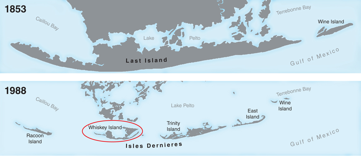
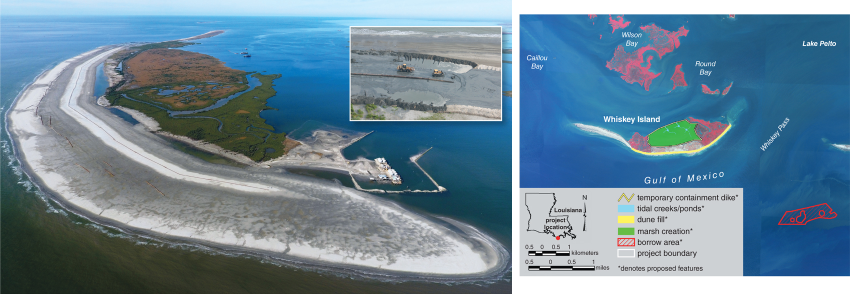
Whiskey Island—one of three barrier islands in the Isles Dernieres Wildlife Refuge—is a prime example of Louisiana’s land loss and the fight to stop it. To reach Whiskey, you take a 40-minute powerboat ride from the Louisiana Universities Marine Consortium research station, in the tiny coastal community of Cocodrie. Your boat navigates a maze of canals that slice through the coastal marsh before entering a massive stretch of open water. Speeding along at 35 knots, you pass shrimp boats, bottlenose dolphins, and oil rigs while dodging clusters of white stakes that mark the sites of submerged barrier islands. Arriving at Whiskey Island, you anchor your boat offshore in the thick, glutinous mud and wade in through waist-deep water.
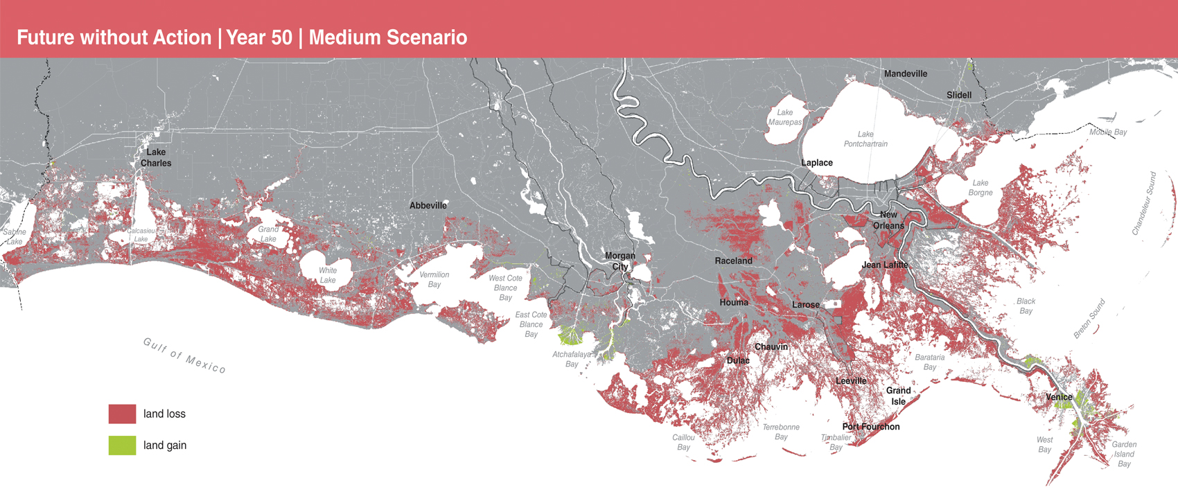
Without the interventions that are underway or under consideration, Louisiana will continue to lose land at extraordinary rates. The map above shows the land that would be lost over the next 50 years if no action is taken, according to the state’s 2017 Coastal Master Plan.
Coastal Protection and Restoration Authority
Whiskey and its neighbors were once a contiguous, 54-kilometer-long barrier island called Last Island. The island was part of an extensive coastal marsh network where locals grazed their cattle and hunted blue-winged teal. The island’s beaches protected this marsh network from the eroding powers of the surf. In 1856, a massive hurricane fragmented Last Island and killed 200 people, and the remnant islands have been steadily eroding ever since. By 2009, a thin strip of beach was all that remained of Whiskey Island. Its bayside marsh was completely submerged, and the island was predicted to disappear by 2019 without restoration.
As Louisiana’s barrier islands disappear, so do the coastal marshes they shelter. The primary causes of land loss in the state are a complex tangle of human-induced and natural factors, including dredging of canals, river diversions, hurricanes, and the natural sinking of the land, exacerbated by resource extraction and sea-level rise. These coastal marshes have long supported Louisiana’s residents, from the indigenous peoples of the Houma and Biloxi-Choctaw-Chitimacha Indian nations to the Cajuns and Creoles who came in the 18th century, and, more recently, the Vietnamese immigrants who now fish these coastal waters. All rely on brown shrimp, oysters, blue crab, and other seafood to feed their families and provide an income. All these species are reliant on coastal marsh health.
Whiskey Island and its neighboring islands were once part of a much larger barrier island, called Last Island, that was 54 kilometers long. An extensive coastal marsh network spanned the island, and its beaches protected the marsh from erosion. In 1856, a hurricane fragmented the land and killed 200 people. The barrier islands, which now make up the Isles Dernieres Wildlife Refuge, have been steadily eroding since then. Whiskey Island’s bayside marsh had completely submerged by 2009, and the whole island was predicted to disappear by 2019 without restoration. Beach and marsh restoration began in 2010.
1853 & 1988 maps Barbara Aulicino adapted from CPRA
In 2010, an event took place that further threatened the future of this beleaguered ecosystem. The Deepwater Horizon oil rig explosion killed 11 people and released 4.9 million barrels of oil into the Gulf of Mexico, making it the worst environmental disaster in U.S. history. The spill affected more than 563 kilometers of southeastern Louisiana’s coastal marshes, killing vegetation and eroding soil in a swath up to 9 meters inland. Although the initial effects of the spill were dramatic, the long-term damage to the many species that rely on coastal marsh health has been difficult to quantify.
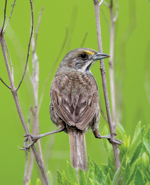
Seaside sparrows are the most saltmarsh-dependent songbird species in North America. They are a species of conservation concern across their range due to coastal land loss. Louisiana seaside sparrows nest in smooth cordgrass and other marsh grasses, and their nests can sometimes flood during high spring tides, which may be increasing with sea level rise. Not much was known about seaside sparrow population dynamics before the 2010 Deepwater Horizon oil spill, but efforts are underway to improve monitoring. A post-spill study by A. Bonisoli-Alquati and colleagues in Environmental Research Letters found that lower seaside sparrow reproductive success in oiled versus unoiled sites could be attributed to direct effects of oil exposure.
Cal Vornberger/Alamy Stock Photo
Before the Deepwater Horizon oil spill, monitoring of the Gulf of Mexico’s marshes was minimal. While most economically important fisheries species have had some form of monitoring to understand population trajectories, little is known about most noncommercial marsh species. Many such species make important contributions to healthy ecosystem functioning. These knowledge gaps have given researchers limited abilities to evaluate how much the coastal marsh ecosystem has changed over time, and how land loss may be influencing the functioning of its wildlife and plant communities. Without “before” data, it has also been difficult to evaluate the oil spill’s full impact on many coastal marsh species. Instead, much of our current understanding of Deepwater Horizon effects comes from post-spill research comparing oiled and unoiled sites.
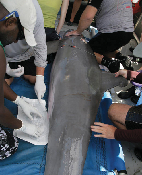
Following the Deepwater Horizon oil spill, biologists from the U.S. National Oceanic and Atmospheric Administration conducted comprehensive physicals on bottlenose dolphins in the Gulf of Mexico (above). At least 900 bottlenose dolphins died as a direct result of the oil spill, but the disaster’s overall impact on the coastal population isn’t well known. There was little bottlenose dolphin monitoring in Louisiana prior to the spill, so it is difficult to make any before-and-after comparisons of the population. However, bottlenose dolphins in coastal areas directly affected by oiling have been found to have serious health problems, such as liver and respiratory diseases. Studies with these findings indicate that oil exposure may therefore have had damaging long-term effects on the Louisiana population. Settlement money from the spill is being used to find new ways to monitor bottlenose dolphins in the Gulf of Mexico. Kaitlin Frasier of University of California, San Diego, and her associates have developed a promising approach using underwater acoustic recording to identify the gulf’s nine dolphin species through their echolocation clicks, which differ between species.
NOAA Permit 932-1905-009526
From such studies, we know that marsh-dependent seaside sparrows fledged more chicks in unoiled sites. Bottlenose dolphins in oiled Louisiana bays have significantly higher prevalence and severity of lung disease after the spill than dolphins in a Florida reference site. Fiddler crab abundance and species diversity was reduced in oiled sites. Such studies are valuable, yet focusing on the “after” does not tell us how big of an overall hit these wildlife populations took or how their numbers have recovered since.
By drawing together several time series data sets, we explore what we know about the current status of marsh species, and identify some of the many gaps in the data that need to be filled (see a more comprehensive series of data sets online: https://www.amsci.org/article /conserving-louisianas-saltmarshes).
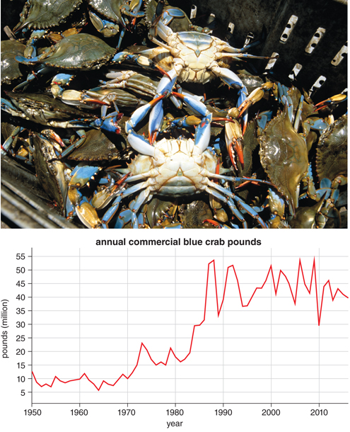
Louisiana has the largest blue crab fishery in the world, and the species has enormous economic and cultural importance for the state. Blue crabs breed offshore, but their larvae swim inland to coastal marshes and estuaries, where they mature before returning to open waters to spawn. Blue crab harvest yields declined following the Deepwater Horizon oil spill in 2010, but rebounded in the years after. The quick recovery may be attributed to temporary fisheries closures directly after the spill, which allowed crab stocks time to rebound.
In the face of an extensive number of lawsuits, in 2016 British Petroleum (BP) agreed to pay out a record-breaking $5 billion settlement to the state of Louisiana. Restoration and monitoring of coastal marshes are key areas of focus for this financial settlement. Studies and projects that have been in planning since the 2010 disaster are now being launched, finally made possible by the recovery funding trickling into the state. With this funding, researchers are using innovative technology and collaborating across organizations to fill key knowledge gaps. These studies will be used to create a baseline for understanding the coming changes to the marsh ecosystem, and represent an important shift in how this ecosystem will be studied and protected in the future. In addition, extensive marsh restorations are being planned and implemented with funding from the settlement, creating much-needed habitat for coastal marsh species.
Just as oil from the Deepwater Horizon spill was reaching its shore in 2010, Whiskey Island was being reborn, the product of years of restoration planning. Offshore sediment had been dredged and pumped into the bay side of the island, replacing open water with 129 hectares of new land. The spill interrupted vegetation planting, but had little overall effect on the new marsh due to protection from the gulf-side beach, which prevented oil from entering the restoration site. Nine years on, a walk in this new coastal marsh reveals an ecosystem teeming with life. As you move through the vegetation, seaside sparrows pop up in curiosity and then vanish back into the thick cordgrass. Marsh wrens and clapper rails scold your presence. Below, hundreds of fiddler crabs flee your next footstep, and juvenile fish and angry blue crabs dart around you in ephemeral pools. Recent monitoring by researchers at the University of Louisiana at Lafayette, including one of us (Byerly), has shown that this marsh restoration has been successful in creating quality wildlife habitat.
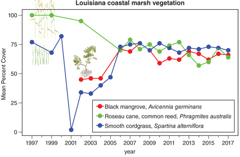
Marsh plants provide the foundation for the ecosystem, by physically holding soil in place and ecologically acting as the basis of the food web. More than 550 kilometers of Louisiana’s coastal marshes were damaged during the 2010 Deepwater Horizon oil spill. Extensive die-offs of oiled smooth cordgrass (blue line) were observed (a drought in 2001 also caused a dramatic drop in percent cover). Although oiled sites had returned to normal functioning 11 months after the spill, areas that had experienced severe erosion due to cordgrass die-offs were unable to recover. Black mangrove (red line), a woody, subtropical shrub, is at the northernmost part of its range in Louisiana. This shrub is intolerant to freezing. As the climate in Louisiana warms, black mangrove is expanding its range. It helps buffer coastal marshes and barrier islands against storm damage. However, if smooth cordgrass declines as a result of the mangrove’s shade, there may be negative consequences. Roseau cane (green line) is one of the most widespread plants in the world. The majority of roseau cane in North America is invasive. However, at least one strain of roseau cane is native to Louisiana’s coastal marshes. Due to its rapid growth and stabilizing root system, roseau cane helps build marsh and prevent erosion. Recently, roseau cane in Louisiana has become threatened by an invasive Asian insect known as the roseau cane mealy bug. This insect has the potential to wipe out whole stands of roseau cane and is spreading rapidly across south Louisiana. Researchers are working to slow marsh loss to the mealy bug because the dead cane stands turn into open water, expediting further land loss in the state.
Paige Byerly/Bethann Garramon Merkle/Megan Hepner
These results from the 2010 Whiskey Island restoration are promising. However, the gulf side of the island, which was directly exposed to the spill, did not fare so well. On Whiskey, as on many barrier islands, oil from the spill killed black mangroves and sediment-stabilizing grasses, hastening the already-extensive beach erosion. As the protective beach disappeared, the newly restored marsh was exposed to overwash from storm surges, shortening the life span of the restoration. But just as the spill threatened the future of Louisiana’s marshes and barrier islands, so is the settlement from it giving them a new lease on life.
In 2018, funding from the Deepwater Horizon settlement was used to create a vast new beach on Whiskey Island. This restoration, which cost $118 million and took more than two years, has created more than 365 hectares of new land, greatly expanding the extent of the island.
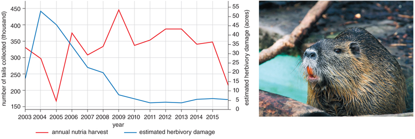
Nutria (right) are wetland rodents related to beavers, native to South America. They feed primarily on grass roots, although their diets have been found to include bird eggs and other varied items. The rodents can eat 25 percent of their body weight in a day. Nutria were introduced to Louisiana in the 19th century as a farmed furbearer. Over time, escaped nutria became established in Louisiana’s vast wetland ecosystems, where they now contribute significantly to wetland loss. In Louisiana’s coastal marshes, nutria eat the roots of stabilizing grasses. The plants die when the roots are consumed, so foraging nutria can rapidly turn healthy marsh into open water. In Louisiana, wetland destruction by nutria was extensive until the initiation of the Coastwide Nutria Control Program in 2002, which pays local trappers a bounty for harvested nutria (red line, right). The program has successfully reduced the amount of damage caused by nutria (blue line), and their numbers have stabilized statewide.
This restoration has not been without controversy. As with most barrier island restorations, the project has only an estimated 20-year life span before further intervention will be needed. Louisiana’s coast is marching inexorably into the sea, and critics argue that the oil spill settlement would be better spent on facilitating the inland migration of coastal human and wildlife communities. Although the restoration is impressive—the largest of its kind in the state—it is just a fragment of the land affected by the spill. The damage caused by the disaster was extensive, and it can never be undone.
Despite these caveats, the Whiskey Island restoration will prolong the life of the marshes of Terrebonne Bay, giving the wildlife and people who dwell in this region more time to respond to the rising tides. As you stand on the pristine new beach and look bayside into the marsh, it is heartening to remember that both were recently open water.
Just as oil from the Deepwater Horizon spill was reaching its shore in 2010, Whiskey Island was being reborn, the product of years of restoration planning (right). Offshore sediment had been dredged and pumped into the bay side of the island, replacing open water with 129 hectares of new land. The spill had little overall effect on the new marsh due to protection from the gulf-side beach. However, the gulf side of the island did not fare so well. Oil killed black mangroves and sediment-stabilizing grasses, hastening the already extensive beach erosion. The loss of the protective beach shortened the life span of the restoration. But just as the spill threatened the future of Louisiana’s marshes and barrier islands, so is the settlement from it giving them a new lease on life. In 2018, some of the Deepwater Horizon funding was used to create a vast new beach on Whiskey Island (left). This beach restoration, which cost $118 million and took more than two years, has created more than 365 hectares of new land, greatly expanding the extent of the island.
Coastal Protection and Restoration Authority; U.S. Department of the Interior/U.S. Geological Survey/National Wetlands Research Center/Coastal Restoration Field Station
The state’s Coastal Master Plan, the blueprint for restoration efforts, outlines $50 billion worth of similar restorations over the next 50 years, with 21 restoration projects planned for 2019 alone. In addition to restorations, extensive efforts are under way to preserve what remains, including installation of rock breakwaters, to reduce the erosive effects of ocean waves, and freshwater diversions, which increase freshwater input into brackish marshes, preventing higher-salinity ocean waters from killing off plants like smooth cordgrass. Combining restoration with preservation will help to further slow the rate of land loss in the state, and the positive outcomes of projects such as those on Whiskey will help guide future restoration efforts, helping to ensure their success.
As is clear in our infographic, other interventions and accompanying monitoring are also making a difference in marsh protection and regeneration. The fight to protect Louisiana’s coast is a desperate one, but it is not without its victories. With new awareness of the importance of coastal marsh comes new appreciation, and a renewed sense of hope for the future of this iconic ecosystem. Whiskey Island is just the beginning.
This piece and the accompanying interactive infographic were developed as a result of OCEANDOTCOMM, a science communication event supported by the Louisiana Universities Marine Consortium, in partnership with Sigma Xi (publisher of American Scientist).
Bibliography
Bonisoli-Alquati, A., P. C. Stouffer, R. E. Turner, S. Woltmann, and S. S. Taylor. 2016. Incorporation of Deepwater Horizon oil in a terrestrial bird. Environmental Research Letters 11:114023.
Coastal Protection and Restoration Authority of Louisiana. 2017. Louisiana’s Comprehensive Master Plan for a Sustainable Coast. Coastal Protection and Restoration Authority: Baton Rouge, LA.
Couvillion, B. R., H. Beck, D. Schoolmaster, and M. Fischer. 2017. Land area change in coastal Louisiana 1932 to 2016: U.S. Geological Survey Scientific Investigations Map 3381, 16 p. pamphlet, doi:10.3133/sim3381.
Deepwater Horizon Natural Resource Damage Assessment Trustees. 2016. Deepwater Horizon oil spill: Final Programmatic Damage Assessment and Restoration Plan and Final Programmatic Environmental Impact Statement. Retrieved from http://www.gulfspillrestoration.noaa.gov/restoration-planning/gulf-plan.
Frasier, K. E., et al. 2017. Automated classification of dolphin echolocation click types from the Gulf of Mexico. PLoS Computational Biology 13(12): e1005823.
Silliman, B., et al. 2012. Degradation and resilience in Louisiana salt marshes after the BP-Deepwater Horizon oil spill. Proceedings of the National Academy of Science of the U.S.A. 109:11234–1123.
Zengel, S., et al. 2016. Deepwater Horizon oil spill impacts on salt marsh fiddler crabs (Uca spp.) Estuaries and Coasts 39:1154–1163.
American Scientist Comments and Discussion
To discuss our articles or comment on them, please share them and tag American Scientist on social media platforms. Here are links to our profiles on Twitter, Facebook, and LinkedIn.
If we re-share your post, we will moderate comments/discussion following our comments policy.