Natural and Unnatural Disasters
By Brian Hayes
Reflections on a city made possible and made vulnerable by reliance on technology
Reflections on a city made possible and made vulnerable by reliance on technology

DOI: 10.1511/2005.56.496
A few years ago I made a pilgrimage to Pumping Station No. 6, which sits athwart the 17th Street canal in New Orleans. Approaching from the intake side, I found a brick building whose entire facade was hidden behind an immense "trash rack," a grille of steel bars that intercept floating debris. Inside, bulbous steel casings enclosed pumps 12 feet in diameter, driven by equally large electric motors. Much of this machinery was installed in 1915 and has a certain antique splendor about it, but the pumps are not museum pieces; they are still among the most powerful in the world. It is these pumps, along with a network of drainage canals and a ring of protective levees, that made it possible to build a sprawling city in the cypress swamps between the Mississippi River and Lake Pontchartrain, where half a million people have been living "below ground zero," as one fleeing resident recently described the place.
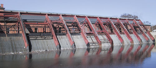
Photograph by Brian Hayes
The pumps are just a small part of the engineered infrastructure that underpins the existence of New Orleans and its suburbs. The entire lower reach of the Mississippi River runs through an artificially stabilized channel. The banks are armored with stone and concrete and surmounted with levees and floodwalls. In some places the course of the river has been straightened; almost everywhere the channel has been dredged. A few miles upriver from New Orleans, the Bonnet Carré Spillway drains flood waters into Lake Pontchartrain. Farther upstream, even bigger spillways at Morganza and Old River divert seasonal overflows into the Atchafalaya River, which empties into the Gulf of Mexico at Morgan City, 50 miles west of New Orleans.
All of this hydraulic engineering has been remarkably successful, at least in the narrow sense that floods on the lower Mississippi have been contained and controlled. New Orleans has not had river water in its streets for more than a century. But the river is not the only threat to the city—and this was already well known even before Hurricane Katrina made it painfully clear at the end of August.
The topography of southern Louisiana is just the opposite of what you would find in an upland river valley. Instead of having a concave profile, where elevations increase as you move away from the river, the delta lands are highest right beside the river bank, where centuries of floods have piled up alluvial deposits. The oldest neighborhoods in New Orleans, including the French Quarter, were built on a particularly high bank on the outside of a sharp bend in the river. As the city grew, however, the only land available was in the "back swamp," which gets lower as it extends north toward Lake Pontchartrain. Much of this area was never more than inches above sea level, and as the land was developed and drained, it sank lower still. Despite the levees and drainage canals and pumps, the "bottom of the bowl" is inevitably subject to flooding.
Craig E. Colten of Louisiana State University gives a chronicle of the city's floods in his recent book An Unnatural Metropolis: Wresting New Orleans from Nature. It's a long list, with two dozen major events in the 19th century alone. In the 20th century, as levees and other protective measures became more robust, urban floods were less frequent; when the barriers did fail, however, the consequences were often more severe. In 1937 the gates of the Bonnet Carré Spillway were opened for the first time; the strategy succeeded in lowering the Mississippi, but Lake Pontchartrain rose so fast that a lakefront levee slumped and allowed water to pour into Jefferson Parish, west of the city. A 1947 hurricane overtopped several levees along the lake shore, flooding 9 square miles in New Orleans and 30 more in Jefferson Parish. In hurricanes Flossy (1956) and Hilda (1964), lake water spilled over the walls of the Industrial Canal, which connects the lake and the river along the eastern edge of the city. Hurricane Betsy in 1965 caused a breach in the west wall of the Industrial Canal, submerging the city's Ninth Ward to a depth of eight feet. Four years later, Hurricane Camille devastated the Mississippi Gulf coast, just as Katrina did this year, but damage was lighter in New Orleans; again, however, a section of the Industrial Canal failed. The canal was also the source of flood water during a 1983 winter storm; in that case, officials neglected to close flood gates.
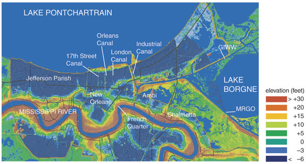
Elevation map courtesy of Louisiana State University. Illustration by Brian Hayes.
The exact sequence of events that led to the post-Katrina inundation has not yet been made clear as I write this in mid-September, but preliminary reports suggest a familiar pattern. Storm winds and tides pushed water up against the south shore of Lake Pontchartrain and into the canals that penetrate from the lake into the city. Again there were breaks in the Industrial Canal, caused, according to some reports, by a barge that broke loose and battered through a concrete wall. On the 17th Street drainage canal—the one that carries the outflow of Pumping Station No. 6—a huge gash opened up sometime on the night of the storm or the following morning. Two more major leaks appeared in the London Avenue drainage canal, a few miles east of 17th Street. According to the Army Corps of Engineers, the two drainage canals failed when water overflowed their concrete walls; the resulting cascade eroded the earthen foundations, eventually allowing the wall panels to topple over. Ivor van Heerden, deputy director of the Louisiana State University Hurricane Center, offers a different view. His analysis indicates that the storm surge was not high enough to overtop the walls, and so they must have collapsed merely from the pressure of the water they were holding back.
It may seem surprising that drainage and navigation canals would so often be the soft spot in the city's flood-control ramparts. The canals are narrow waterways, protected from the wind-driven waves that pound levees facing Lake Pontchartrain. But there is another risk factor that may help to explain the vulnerability of the canals. Whereas lake levees are erected atop embankments at sea level or above, the canals extend into areas of the city where the ground lies 5 or 10 feet below sea level. Hence the walls of a canal must be taller and built to withstand greater pressure at the base. The canals also pass through urban neighborhoods where land is scarce, and so the canal walls tend to be more-vertical structures.
Brian Hayes
Once the floodwalls failed, the network of pumping stations could not possibly save the city. The aggregate capacity of all the pumps in New Orleans is a little less than 50,000 cubic feet per second. This is a mammoth flow—roughly equal to the mean discharge of the Missouri River—but the influx of lake water through the burst flood walls was an order of magnitude greater. The pumping stations themselves were soon flooded. Even if they could have kept running, their effort would have been pointless. The discharge from Pumping Station No. 6, for example, would have immediately poured back into the streets through the hole in the 17th Street canal.
Flooding in areas east of New Orleans, such as the hard-hit neighborhoods of Chalmette and Arabi, apparently followed a different time course. Whereas most of the city remained relatively dry until the morning after the hurricane passed, the eastern suburbs were submerged during the night of the storm. The water that washed over those places probably came not from Lake Pontchartrain to the north but more directly from the Gulf, across Lake Borgne to the east. A particular point of vulnerability is the V-shaped area where two major canals converge. The wind-driven water may have reached a depth of 20 feet there, far above the levees. This surge may have also entered and overflowed the Industrial Canal, causing at least some of the flooding in eastern wards of the city.
Experts on hurricanes and on New Orleans say that no one should have been surprised by the impact of Katrina on the city. As mentioned above, many earlier storms had similar effects, although at lesser magnitude. Computer models constructed by workers at the Louisiana State University Hurricane Center predicted that a storm of Katrina's strength would produce "back door" flooding from Lake Pontchartrain and the canals. In 2002 a prescient series of articles by John McQuaid and Mark Schleifstein, published in The New Orleans Times-Picayune, brought the results of those simulations to public attention. Just a year ago, emergency planners from the area took part in an exercise focused on a fictitious Hurricane Pam whose effects on the city were quite similar to those of Katrina.
After Hurricane Betsy in 1965, the Army Corps of Engineers drew up a plan to reduce the risk of flooding in New Orleans and other communities on Lake Pontchartrain. The key element of the plan was a system of movable gates to be erected in the narrow passages that connect the lake with the sea. Most of the time, the gates would be left open to allow the free ebb and flow of tides. When a major storm approached, the gates would be closed to seal off the lake from rising Gulf waters. The idea was inspired by the tide gates in the Netherlands designed in the aftermath of a 1953 flood. Another gate guards the Thames basin in Britain.
The Corps' proposal for a storm barrier in Lake Pontchartrain was approved by Congress in 1966, but a decade later construction was just getting under way when a federal court halted the project because of concerns about its effects on the lake environment. By the mid-1980s the storm-barrier proposal had been shelved, and the Corps embarked on a more modest plan for extending and shoring up th network of levees and floodwalls. Even that project has been going slower than expected. A fact sheet issued by the Corps in May of 2005 states, "The major remaining construction is the parallel protection along the London Avenue and Orleans Avenue canals. Completion of this work is scheduled by 2010." (A Corps news release on September 7 said the failures in the 17th Street and London Avenue canals were in places where all scheduled upgrading work had already been completed.)
State and city officials have complained of delays and skimpy budgets for flood-control projects in the past five years. In fiscal year 2005 the Corps requested $22.5 million for the Lake Pontchartrain project, but the budget proposal submitted to Congress by the Bush administration allocated only $3.9 million; Congress increased the amount to $5.5 million. The Corps' fact sheet notes that "Seven contracts are being delayed due to lack [of] funds." For fiscal year 2006 the administration's proposed appropriation fell further to $3.0 million, and the overall budget of the New Orleans District of the Corps was cut by $71.2 million.
Meanwhile, other critics argue that the Corps has done too much rather than too little. Flood-control measures, they say, have hastened the loss of coastal wetlands that might have shielded the city from the storm. At the southern margin of Louisiana, land can remain above the waves only with continual replenishment from river-borne sediment. Dams on the upper Mississippi and its tributaries have reduced the river's load of silt, and much of what remains pours directly into the deep waters of the Gulf instead of spreading out over the flood plain. As a result, the land area of southern Louisiana is shrinking by 25 to 35 square miles per year. The Corps has denied that the loss of wetlands "was a contributing factor in the situation." On the other hand, the Corps also stands ready to solve the problem of wetland loss, through a $14 billion restoration project called Coast 2050. But apart from small pilot studies, the plan has never been funded.
As New Orleans and the other stricken communities of the Gulf Coast begin rebuilding, they will doubtless give much thought to protecting themselves from the next big storm. Levees and flood walls will be strengthened, perhaps the plan to install storm gates at the entrances to Lake Pontchartrain will be revived, and work to restore coastal wetlands may finally win funding. Protective measures for the beachfront communities of the Mississippi coast are harder to engineer, but perhaps this occasion will be taken as an opportunity to move at least some structures farther from the surf zone.
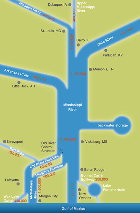
Given the century-long history of "back door" flooding in New Orleans, the Corps of Engineers and other flood-control agencies may well be criticized for devoting too much energy to the Mississippi River while neglecting the hurricane hazard. But in fact the river remains the greatest force of nature in the region. Before Katrina, the worst disaster in Louisiana—and one of the worst in the nation's history—was the Mississippi flood of 1927, in which nearly a million people were forced from their homes. In that case the city of New Orleans was spared—but only by dynamiting a levee downstream, wiping out much of Plaquemines Parish. On the Lower Mississippi, floods of this magnitude can happen only when several major tributaries (the Ohio, the Upper Mississippi, the Missouri, the Arkansas) all rise at once. Such an unfortunate coincidence is rare, but eventually it is bound to happen again.
Ironically, New Orleans also faces the contrary risk: being left high and dry. Two hundred miles upstream, the Old River Control Structure diverts flood waters into the Atchafalaya River, but the gates and weirs there have another purpose as well: They are intended to prevent the Atchafalaya from "capturing" the entire flow of the Mississippi, leaving New Orleans and Baton Rouge stranded on a stagnant backwater. The Atchafalaya takes a shorter and steeper route to the Gulf, and so physics is on its side. In 1973 the Control Structure was nearly washed away; if it had failed, the outlet of the Mississippi would now be at Morgan City—except that Morgan City would also have been washed away. Following that close call, the Corps of Engineers added another complex of gates at Old River. It is a great mass of concrete and steel, and yet it looks delicate enough when you reflect that whole cities depend on this structure for their wellbeing and maybe their existence.
© Brian Hayes
Editor's note: Brian Hayes, whose "Computing Science" customarily appears in this space, became acquainted with flood control on the Mississippi while writing his just-published book Infrastructure: A Field Guide to the Industrial Landscape (W. W. Norton). After Hurricane Katrina struck, we asked him to contribute a short essay on the battered infrastructure of New Orleans. "Computing Science" will return next issue.
Click "American Scientist" to access home page

American Scientist Comments and Discussion
To discuss our articles or comment on them, please share them and tag American Scientist on social media platforms. Here are links to our profiles on Twitter, Facebook, and LinkedIn.
If we re-share your post, we will moderate comments/discussion following our comments policy.