
This Article From Issue
July-August 2011
Volume 99, Number 4
Page 346
DOI: 10.1511/2011.91.346
LISTED: Dispatches from America’s Endangered Species Act. Joe Roman. viii + 360 pp. Harvard University Press, 2011. $27.95.
I don’t recall exactly when or how I discovered Roadside Geology of Northern California, but it was some time in the mid-1970s, when I was a student in the Golden State. Since then I’ve accumulated numerous other volumes in the Roadside Geology series, and their availability has at times strongly influenced where vacations take me.
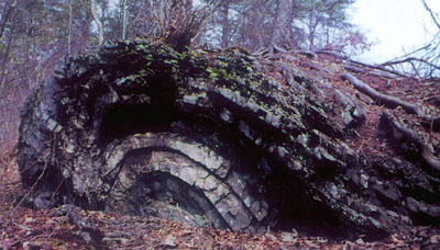
From Roadside Geology of Maryland, Delaware and Washington, D.C.
Ad Right
The Roadside Geology books are aimed not at rock collectors but at amateur geology enthusiasts. Written by geologists (mainly academics) for nonprofessionals, they are accurate and not overly dumbed down. Their aim is generally to put what you can see from the highway, or near the highway, in the context of the geological processes that formed the region. For me, they’ve long been associated with those magic words: road trip!
I discovered recently that the series has undergone a major transformation. When I came across a copy of the latest volume, Roadside Geology of Maryland, Delaware and Washington, D.C. (Mountain Press, $24), by John Means, I eagerly opened it, to be greeted by—color! Most of the photographs and all of the illustrations—beautifully prepared by Matthew Moran and Suzanne Moran—are four-color throughout the book. The color makes the beauty of the rocks all the more evident and is vital to the geological maps that are included. This is an enhancement that I am more than happy to pay a few extra dollars for. (I’ve since learned that the Connecticut and Florida editions, which were published in the past few years, also have color.)
One of the places that the latest book’s road guides have me itching to visit the next time I find myself in the D.C. area is Great Falls, where highly erosion-resistant metagraywacke of the Mather Gorge Formation causes the Potomac River to plunge 60 feet in half a mile. Above, an exposure of the Devonian Brallier Formation along Fifteen Mile Creek in western Maryland reveals shale that was once plastic enough to be folded into compact anticlines.
American Scientist Comments and Discussion
To discuss our articles or comment on them, please share them and tag American Scientist on social media platforms. Here are links to our profiles on Twitter, Facebook, and LinkedIn.
If we re-share your post, we will moderate comments/discussion following our comments policy.