
This Article From Issue
September-October 1998
Volume 86, Number 5
DOI: 10.1511/1998.37.0
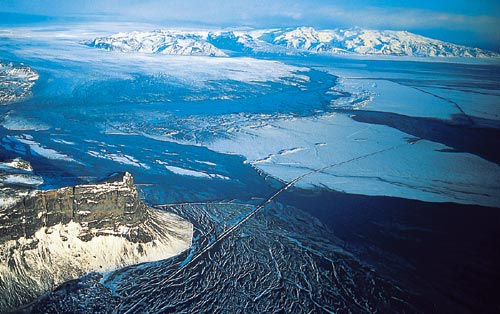
Vatnajökull, Iceland's largest ice cap, blankets approximately 8,100 square kilometers of the aptly named island's surface in ice averaging almost one-half kilometer in thickness. At the temperate glacier's southeastern margin, two major tongues spill summer melt into the Iceland Basin of the North Atlantic. Located at 65 degrees north latitude at the tip of the Mid-Atlantic Ridge, Iceland also holds the distinction of being one of the most poleward locations of active volcanism—sometimes beneath the ice. And when fire and ice meet, the Icelandic people have a word to describe the glacial flood that's often the result—jöklhlaup (yo-kuhl-h-lowp).
AP / Wide World Photos
Ad Right
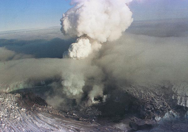
According to Oddur Sigurdsson, a geologist with the Icelandic National Energy Authority, a number of volcanoes beneath Vatnajökull have been active this century, but by far the most active has been one called Grímsvötn. On September 29, 1996, seismometers detected an earthquake of magnitude 5.4 under Vatnajökull, followed by clusters of quakes of somewhat lower magnitude. A day later, the seismic activity subsided, only to be replaced by volcanic tremors. On the morning of October 1, aerial reconnaissance revealed that the surface of the ice was developing a depression between the caldera of two volcanoes. But later that day, the surface of the ice over the Grímsvötn caldera, at the southeastern end of the forming fissure, had risen by 10 to 15 meters. Then, early on the morning of the 2nd, an eruption broke through the surface of the ice, emitting an ash cloud that reached an altitude of 10 kilometers on the 3rd.
Oddur Sigurdsson
Icelandic geologists have calculated that the heat transfer to ice from the eruption was approximately 1018 joules of energy—the equivalent of a Hiroshima nuclear weapon every minute for a week—and some energy was lost into the air. The volcano quieted on the 13th, but ice continued to melt and, over the course of the next month, formed a 6-to-7-kilometer-long fissure in the glacial bed of Vatnajökull, melting more than 3 cubic kilometers of ice. Unfortunately, little of this water worked its way to the glacial exits 50 kilometers away at the coast. The Grímsvötn caldera and an ice dam held it back. Through the rest of October, Sigurdsson and his colleagues waited for the inevitable.
AP / Wide World Photos
Late on November 4 seismic activity at Grímsvötn indicated that the ice dam had finally broken, and at 7:20 a.m. on the 5th, meltwater burst vertically and explosively from the surface of the glacier two to three kilometers above its tongue. The water flowing from Grímsvötn may actually have lifted the 600- to 800-meter-thick glacier as much as a meter before it broke through. By 4:00 on the afternoon of the 5th, the long-awaited jöklhlaup was in full swing. The flood front—a mixture of meltwater and entrained ice and sediment—moved from the full 20-kilometer width of the glacier's terminus (its edge) at a speed of about 10 kilometers per hour, forming standing waves 3 to 4 meters high. By midnight that night, the total flow in the five outwash channels peaked at over 50,000 cubic meters per second, making it the second largest river on earth.
AP / Wide World Photos
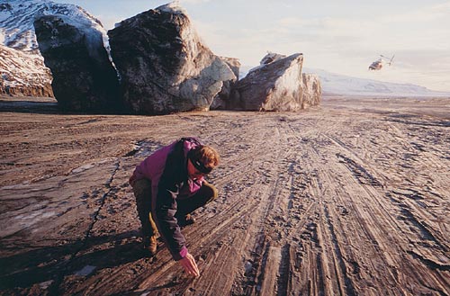
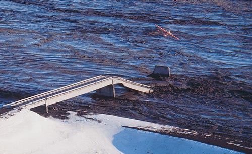
While the 1996 jöklhlaup proceeded to add 7 square kilometers to the area of Iceland, it also erased completely a 376-meter-long bridge, along with a fifth of a 900-meter bridge, 12 kilometers of road, 7 kilometers of dikes and 23 power-line towers, doing $14 million (U.S.) in damage. The second largest jöklhlaup of this century—a 1918 event on a different ice cap exceeded this one by five times!—it moved at least 180 million tons of sediment (probably much more) along with 3.4 cubic kilometers of water onto and across the outwash plain Skeidarársandur.
As awesome as the power of the 1996 jöklhlaup was, however, it may pale before the intensity of activity during the last ice age, when all of Iceland was ice covered. Sediment cores analyzed by C. Lacasse at GEOMAR in Kiel, Germany, and his colleagues at the University of Rhode Island show extensive deposition of volcanic sediments during the Holocene age (beginning about 11,000 years ago). These sediments formed fans in the Icelandic Basin and can account for 30 percent of the sediment column in some cores. Individual gravitational flows, composed of more than 50 percent volcanic material, exceed one-half meter in thickness—far thicker than sediments deposited by the largest jöklhlaup of this century.
The Icelandic experience with this volatile mixture of volcanism and glaciation has, in one way, been fortuitous. Icelandic scientists were well prepared for the 1996 jöklhlaup: Although its size was something of a surprise, there were no fatalities or even injuries, and the event's behavior was carefully studied. Their work may be helpful in predicting the retreat of glaciers during global warming, which also can have severe consequences. Bruce Molnia, with the U.S. Geological Survey, has been investigating the Bering Glacier in Alaska as it retreats. In 1994, the ice dam containing Berg Lake was breached, allowing 5.5 cubic kilometers of water to escape in 72 hours, lowering the lake's level by 110 meters. There's every reason to think that the future holds more of the same.
Glacial melting need not be catastrophic, but neither can it be modeled by the demise of ice cubes in a glass. When what took millennia to form comes apart in mere days, it's little wonder folks give the event a name of its own.—David Schoonmaker
American Scientist Comments and Discussion
To discuss our articles or comment on them, please share them and tag American Scientist on social media platforms. Here are links to our profiles on Twitter, Facebook, and LinkedIn.
If we re-share your post, we will moderate comments/discussion following our comments policy.