Internal Tides and the Continental Slope
By David Cacchione, Lincoln Pratson
Curious waves coursing beneath the surface of the sea may shape the margins of the world's landmasses
Curious waves coursing beneath the surface of the sea may shape the margins of the world's landmasses

DOI: 10.1511/2004.46.130
For many of us, a drive to the ocean is, at the very least, a yearly pilgrimage. Imagine for a moment what it would be like if, during one of these trips, you arrived at the beach to discover that the water was gone.
After getting over your initial disappointment, you would probably decide that exploring what had been hidden territory would be just as much fun as playing in the surf. So you'd drive on cautiously, wondering what was in store.
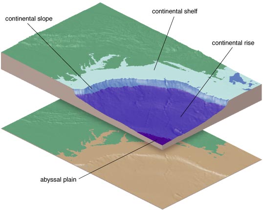
At first it's easy going: You are traversing the continental shelf—a nearly flat plateau made of sediments eroded from the land. To the left and right, you might spy relict river channels, which were formed during former ice ages when the buildup of glaciers lowered sea level by more than 100 meters, exposing the continental shelf to the open air (truly). Here and there on this largely flat plain, you could happen on fields of ripples or maybe even dunes, which were created by the motion of waves and current in the now-missing ocean.
Driving farther, you eventually arrive at the edge of the continental shelf. Depending on where you are in the world, this change could come just 5 kilometers out from shore (as it does, for example, off central Chile) or more than 100 kilometers (the situation for much of the East Coast). Here, where the ocean used to be more than 100 meters deep, you stop your car and get out to take in the magnificent view. Before you is the continental slope, which descends some 3 kilometers vertically as it ramps downward toward the abyssal ocean floor. This incline represents the seaward face of the vast pile of sediments eroded from the interior of the continent and deposited along its watery edge by rivers, waves, currents and, in some regions, glaciers.
As with the continental shelf, the surface of the continental slope varies from place to place. There are spots where the shelf drops off precipitously and where the descent to the base of the slope is quite rugged. This is generally the case where submarine canyons—some of which are larger than the Grand Canyon—cut into the continental slope. But between these chasms, the ground falls away much more gradually: If you were to climb back in your car and drive down such a slope, it would be like descending a steep highway pass out of the Rockies or the Appalachians.
What is perplexing (and thus intriguing) for marine geologists is the question of why the continental slope is not any steeper. When only gravity acts on them, sediments piled underwater can easily maintain stable slopes of 15 degrees or more. Yet some 80 percent of the continental slopes around the world dip downward at less than 8 degrees, and their average incline is only about 3 degrees. Acting alone, the constant influx of sediment eroded from the land would tend over time to steepen the grade, so, clearly, one or more natural forces are ensuring that these slopes remain low. We believe that a primary factor—one not recognized before—is something called the internal tides: submerged waves largely hidden from view that pulse through the body of the ocean with the same twice-daily period as the normal lunar tides.
Waves moving along the surface of the sea are easy enough to understand, but how can there be waves within the ocean? The simplest way to grasp this strange concept is first to remember that surface waves are, in fact, traveling along the interface between two fluids: air and water. Now imagine that the upper fluid were a liquid instead of a gas; what would happen? There could still be waves at the interface, but they would act somewhat strangely. If, for example, the upper liquid is only a little bit less dense than the lower one, the waves at the interface would seem to have bizarrely large amplitudes, and, intriguingly, they would appear to move in slow motion. (These same effects can be clearly seen in the little wave tanks sold at novelty stores, usually next to the lava lamps).
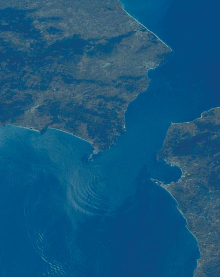
Courtesy of NASA.
Similar interfacial waves exist within the ocean. They often form at the base of what oceanographers call the mixed layer, the topmost stratum of the sea, which, being churned around constantly by the wind and waves, is rather homogenous in its physical properties. Beneath the mixed layer the temperature (and hence the density) of seawater changes abruptly. (Scuba divers are sometimes surprised as they pass from the warmer sunlit surface zone through the base of the mixed layer and into to the much colder waters below.) The base of the mixed layer is usually less than 100 meters deep, and the interfacial waves that form at such modest depths are not relevant to shaping the continental slope, which lies deeper down. The internal waves that influence the continental slope are rather different in that they require no distinct density interface. Rather, they form simply because the water gets gradually denser with depth.
To help understand how internal waves can arise in such situations, you might imagine for a moment tagging a small parcel of seawater in some way, perhaps by filling a balloon with water at some depth in the sea and then allowing it to float freely at that level. What would happen then if you were to lift the balloon upward where the water is less dense? Because the water that fills the balloon is denser than its new surroundings, gravity would pull the balloon back down. But the momentum it gains during descent would make it overshoot its equilibrium po-sition, and the descending balloon would soon find itself surrounded by water that is denser than the water it contains. Up then it would go, continuing this vertical oscillation until friction brought things eventually to rest.
With a mental picture of this bobbing balloon in mind, it is not hard to see how such up-and-down motions could be generated within the ocean. One source of energy for driving these oscillations is the daily tides. Although people normally think of the tides as being responsible for changing sea level, they also cause current to move over the ocean bottom, where the flow sometimes encounters submarine mountains and ridges. Deflected by such topographic obstacles, tidal currents can easily generate up-and-down motions, which propagate away from the source in great waves that share the same 12-hour period as the familiar twice-daily ocean tides. These waves constitute what oceanographers call the semi-diurnal internal tides.
The pioneering Norwegian ocean-ographer (and noted humanitarian) Fridtjof Nansen discovered the first examples of internal waves in the Arctic basin at the end of the 19th century. But not until the 1960s did oceanographers become aware that internal waves (and tides) are ubiquitous, that they contain huge amounts of energy and that they regularly mix ocean water as they slosh along the continental slopes.
It was during that lively decade—a phenomenally influential one for Earth science—that one of us (Cacchione) and his Ph.D. advisors at the Massachusetts Institute of Technology, Carl Wunsch and John Southard, first postulated that internal waves could, over geologic time, act to shape the seafloor. Wunsch, a prominent physical oceanographer, had done calculations predicting that internal waves moving up undersea slopes must cause strong currents along the bottom. But at the time Wunsch's theory needed to be tested under controlled laboratory conditions, something Cacchione did as part of his thesis work.
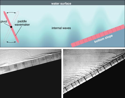
That exercise required a rectangular tank that simulated the real ocean. Wunsch and Cacchione thus made sure that the water in the tank had an increasing concentration of salt (giving the water increased density) with depth. They then generated a series of internal waves using a mechanical paddle that oscillated back and forth about a horizontal pivot centered in the water. This geometry produced simple internal waves in which horizontal water velocities were maximum at the top and bottom of the tank and zero in the middle. These waves traveled from one end of the tank to the other, where a tilting plastic bottom mimicked the continental slope.
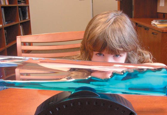
David Schneider
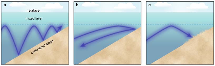
In these experiments, dramatic changes to the internal waves arose over the simulated slope, just as Wunsch's theory had predicted. When the waves encountered the plastic incline, their amplitudes grew, their horizontal wavelengths shortened, and water velocities increased—similar in many ways to what one sees when surface water waves hit the beach. In some instances, the internal waves formed tidal bores (large, turbulent, wall-like waves with abrupt fronts), which traveled upslope and then broke up. These breaking internal waves often caused a great deal of swash and backwash, which in the real ocean would scour the bottom.
With their test tank, Cacchione and Wunsch explored a special "critical" condition in which the energy of the internal waves essentially became trapped in a narrow zone along the inclined floor of the tank. At the time, this phenomenon had not been described theoretically, but with their experimental investigation, Cacchione and Wunsch discovered that under this critical condition, water velocities and internal breaking were greatly intensified along the faux slope, well beyond what they had observed for other experimental runs. In subsequent laboratory experiments, Cacchione and Southard demonstrated that internal waves could resuspend bottom sediment and create sediment ripples. Seeing these effects, Cacchione, Wunsch and Southard proposed that if the critical condition were satisfied along continental slopes in the real ocean, internal waves might well control sedimentation.
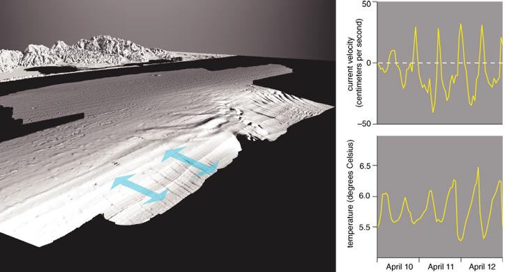
Although Cacchione had studied internal waves extensively in the laboratory as a graduate student, his first personal experience with their effects took place years later within Hydrographer Canyon, which lies just south of Cape Cod, during a dive in NR-1, a nuclear-powered research submarine of the U.S. Navy. While Cacchione and noted marine geologist Bruce Heezen were busy mapping the seafloor and taking photographs within this canyon (one of many that cut into the continental slope in this region), strong currents buffeted the vessel. The maximum speed of these currents was about a half-meter per second near the seafloor, and they reversed direction every 12 hours or so. Unlike other nuclear submarines, NR-1 has small windows, which allowed the scientists aboard to witness the periodic pulses of muddy water the strong currents raised. These undersea mudstorms obscured the otherwise clearly visible seabed for an hour or so, just as the tidal currents reached their highest speeds. This experience convinced Cacchione that internal waves could indeed move sediment along the seafloor and motivated his continued exploration of this phenomenon.
Barbara Aulicino
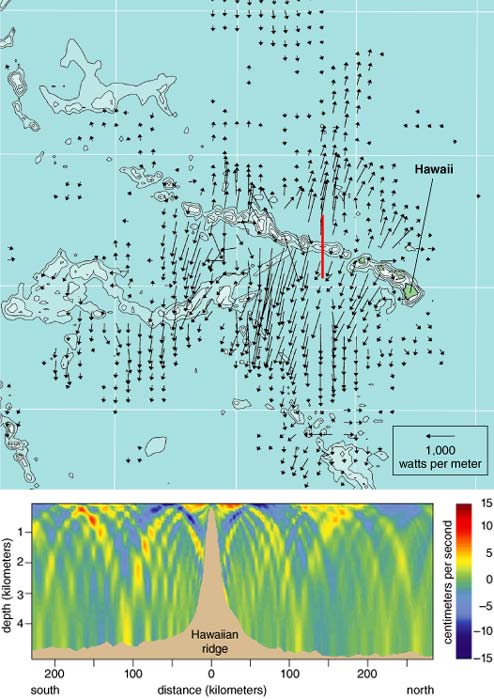
Research dives elsewhere, along with numerous measurements from moored instruments, have since documented the universality and power of the internal tides both within submarine canyons and over other, more regular areas, where the strong bottom currents presumably have important effects. For example, investigators at the University of Washington monitored the influence of internal waves and tides using an instrumented mooring that they maintained in about 450 meters of water on the upper continental slope off northern California from 1995 to 1999. Throughout the five years of study, internal tides were consistently responsible for the strongest flows near the bottom. The fastest bottom currents reached 40 centimeters per second—pulses of colder water, which moved upslope as an advancing tidal bore, mixing the bottom waters with vigor. Oceanographers have found similar goings-on at many other places such as off Oahu, Hawaii, (at about 460 meters depth), off Virginia (at about 1,100 meters depth), and off southwest Ireland (at about 3,000 meters depth, at the base of the continental slope).
The wealth of recent evidence for the internal tide creating bottom currents strong enough to prevent deposition and sometimes even to erode accumulated sediments prompted us to reconsider the idea that this process might indeed control the geologic evolution of the continental slope. Of course, many other natural phenomena are known to affect this portion of the sea bottom—everything from the tectonic movements of the lithospheric plates to the episodic scouring action of turbidity currents, essentially underwater mudslides, which arise, for example, when a portion of the seafloor gives way, sending a dense mixture of water and sediment tumbling down submarine slopes. The rates, frequency and spatial extent of these processes vary from one continental margin to the next, which makes it rather difficult to evaluate their overall influence in shaping the continental slope. The internal tides are different. They pass over continental slopes all around the planet, every day of every year and have done so, in some parts of the globe, for more than 100 million years. Internal tides have an omnipresence that approaches the tug of gravity, making them a prime candidate in our minds for the cause of the low overall gradient of the continental slope.
Two years ago we set out to evaluate this notion. Understanding our strategy is not difficult but requires learning a little more about how internal tides work.
Unlike surface waves, the energy of the internal waves can propagate not only horizontally but also vertically and any direction in between. The angle of propagation—"the characteristic angle"—depends only on frequency (in this case, two cycles per day), on geographic latitude and on how the water changes density with depth. If the characteristic angle is greater than the dip of the seafloor, the energy of the internal tide propagates into shallow water as it bounces between the base of the mixed layer and the seafloor. If the characteristic angle is shallower than the dip of the seafloor, the energy of the internal tide caroms off the base of the mixed layer, then down to the bottom and finally back out to the open sea.
Between these two extremes lies the interesting case where the characteristic angle is just equal to the slope of the seafloor—the critical condition that Cacchione and Wunsch had studied in the laboratory. Under this special circumstance, the energy of the internal tides is trapped along the bottom, and current velocities reach a maximum, which tends to keep any sediment that the water holds in suspension. Thus when the angle of propagation matches the dip of the sea bottom, internal tides could prevent sedimentation.
The density structure of the oceans is such that the characteristic angle of the internal tides is typically between 2 and 4 degrees. Is it merely a coincidence that continental slopes around the world are generally inclined at about 3 degrees—that is, at just the angle that causes the bottom currents from internal tides to be at or near their strongest? We think not. Rather, we suspect that the internal tides create bottom currents that are sufficient to prevent the sediments swept over the edge of the shelf from accumulating on the continental slope and steepening it beyond the local characteristic angle.
To test this idea, we (along with A. S. Ogston, a colleague at the University of Washington) examined the correspondence between the characteristic angle of the internal tides and the dip of the continental slope at two places where the ocean bottom has been mapped in excellent detail: off the shores of northern California and off southern New Jersey. The comparison of these two locales is telling because they differ in several important ways. For one, the slope near northern California is part of a narrow continental margin, which is located along the boundary between two tectonic plates that are colliding into each other. These motions continuously deform the seabed and cause frequent earthquakes, some of which trigger submarine avalanches. By contrast, the New Jersey slope is part of a wide continental margin, one located within the relatively quiet interior of a tectonic plate. Earthquakes here are far weaker and less frequent, and tectonic deformation largely ceased more than 100 million years ago.
Another marked difference between the two regions involves the source of their seafloor sediments. Northern California's Mad and Eel rivers have among the highest sediment yields of all rivers in the United States, and a significant fraction of this copious supply makes it onto the nearby continental slope. In contrast, little sediment accumulates offshore from New Jersey, where the continental slope is covered with very fine sediments eroded from the continental shelf and swept over the shelf edge.
The oceanographic conditions in the two areas differ as well. Historical measurements show that the seasonal differences in the way density varies with depth over the continental slope are larger in the Atlantic off New Jersey than they are in the Pacific off northern California. As a result, the geometry of the internal tides changes more over the course of the year off the Jersey shore than it does off northern California.
The key question at the outset of our study was whether the characteristic angles in these two places match the local dip of the continental slope. Using water temperature and salinity measurements compiled by the National Oceanic and Atmospheric Administration, we worked out the average density structure of the ocean in the two study areas and then derived the characteristic angles for the internal tides. Remarkably, the mean characteristic angle in each study area equaled or nearly equaled the mean gradient of the local continental slope: Both quantities are about 2 degrees in northern California and about 4 degrees in southern New Jersey.
We went on to examine the correspondence between the characteristic angle of the internal tides and the incline angle of the continental slope in more detail using highly resolved measurements of the seafloor, which are available for these two study areas. Members of the U.S. Geological Survey and academic investigators participating in a program of the Office of Naval Research called strataform (an abbreviation for "STRATA FORmation on continental Margins") collected this detailed topographic information using a technique called swath mapping. That method uses a research vessel equipped with an array of acoustic transducers mounted on the bottom of the hull. These devices broadcast sound energy down to the seafloor in a fanlike series of beams that extend both to the left and right. In this way, technicians on board can map the depth of the water over a wide swath centered under the path of the ship. And using both historical and more recent soundings of water temperature and salinity in these areas, it was easy enough for us to compute the characteristic angles of the internal tides for a dense array of geographic grid points and then compare these angles with the slope of the seafloor at those same spots.
The results turned out to be more complicated than with our general analysis, but they nevertheless supported our suspicion that internal tides help to shape the continental slope. In the New Jersey study area, large sections of the slope between the depths of 200 and 2,000 meters dip at an angle that is at or nearly equal to the characteristic angle of the internal tides at one time of the year or another. In winter, this correspondence even holds up in the interiors of many submarine canyons, such as the central portion of Hudson Canyon, where internal tides are known to cause high-velocity currents. Open-slope regions in deeper sections also lie close to the characteristic angle of the internal tides, but at other times of the year. For example, during summer the characteristic angle matches the slope of the seafloor over much of the Hudson Apron, a large expanse immediately south of Hudson Canyon where erosion is minimal and deposition dominates. In such settings internal tides would be expected to have their greatest influence, and the close correspondence between the dip of the Hudson Apron and the local characteristic angle suggests that internal tides do indeed control the amount of incline one finds on the sea bottom there.
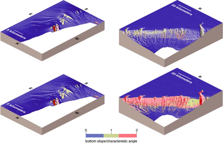
The continental slope off northern California also provided some important evidence. Because of the tectonic deformation going on along the West Coast, portions of the slope in the central and southern sections of our western study area have large relief, reflecting the ongoing action of tectonic uplift and folding as well as a history of undersea landslides. Despite the presence of these confounding processes, segments of the slope between 200 and 450 meters depth dip at or near the characteristic angle for the internal tides. The strength of the bottom currents measured at this site suggests that internal tides can control sedimentation and hence the shape of at least some of the continental slope. Admittedly, here (and elsewhere on the seafloor) other processes are at work too. In particular, marine geologists have long been well aware of the fact that earthquakes trigger turbidity currents from time to time, and these muddy flows can move a lot of sediment into deeper parts of the ocean. However, based on the universality of the phenomenon and its persistence over geologic time, we believe that the internal tides deserve to be credited as a primary influence shaping the overall configuration of the continental slope.
We will soon be mounting investigations of the continental margins in other parts of the world to test the correspondence we have found so far between the dip of the slope and the characteristic angle of the internal tides. We believe that the results will confirm our expectations, but, of course, we have to be prepared for some surprises. Perhaps we will find evidence that the simple picture we derived from looking at California and New Jersey is, in fact, not so tidy after all. Or maybe the suggestive correspondence we found will indeed prove to be universal. Only time (and, well, tide) will tell.
Click "American Scientist" to access home page
American Scientist Comments and Discussion
To discuss our articles or comment on them, please share them and tag American Scientist on social media platforms. Here are links to our profiles on Twitter, Facebook, and LinkedIn.
If we re-share your post, we will moderate comments/discussion following our comments policy.