In Search of Better Skies: Harvard in Peru I
By J D Fernie
Establishing an observatory in 19th-century South America
Establishing an observatory in 19th-century South America

DOI: 10.1511/2000.35.396
Like many an old codger before me, I'm rather given these days to reflecting on the changes that have transpired over the years of my career. Naturally, I quite often come to the standard old-codger conclusion that things have pretty much gone to the dogs, but one thing that is now indisputably better is the life of the observational astronomer. When I was a graduate student in the mid-1950s, one almost always had to carry out observations with whatever local telescope was available in whatever climate one's location offered, usually far from the best. National or consortium facilities at carefully chosen first-rate sites were mostly yet to come. When they did, they resulted in a generation of astronomers in what seemed almost perpetual flight between home and observing sites. Today we are returning to a world of stay-at-homes, but now sitting in front of their computers using the Internet to control a telescope and data acquisition half a world away, if not in outer space.
Nevertheless, the idea of creating field stations at desirable locations where data could be obtained and sent to home base for analysis goes back a long way. It received particular impetus in the late 19th century when photography entered astronomy. Photographs could be taken relatively quickly at the distant site and then returned home for leisurely analysis by experts. Take the case of the Harvard College Observatory.
It began with the death of Uriah Boyden in 1879 at the age of 74. Boyden had been a practical Boston engineer/inventor of some repute, and probably surprised everyone when he left nearly a quarter of a million dollars to whatever astronomical institution could convince his trustees that it would build an astronomical observatory on a mountain "at such an elevation as to be free, so far as practicable, from the impediments to accurate observations which occur in the observatories now existing, owing to atmospheric influences." Boyden had been mildly eccentric, but his heirs saw this as eccentricity run rampant, especially since it consumed almost his entire fortune.
A legal battle of considerable proportions ensued, but eventually the will was declared valid. Among those who took note was Edward Pickering, director of the Harvard College Observatory, who had for some time had an interest in the idea of a field station. In fact, he wanted two: one in the northern hemisphere and one in the southern, so the entire sky would be available for Harvard's research. There were further years of delay while the trustees consulted endlessly, but eventually, in 1887, Pickering won the Boyden Fund for Harvard.
Pickering decided on Southern California for the northern station, and word soon reached him that there was already local enthusiasm for establishing an observatory outside Pasadena on what was then called Wilson's Peak. The local enthusiasm came about because Northern Californians had recently acquired the Lick Observatory a little south of San Francisco. James Lick had been a millionaire who had been persuaded, with some difficulty, to build the observatory as a monument to himself instead of a pyramid rivaling that of Cheops in downtown San Francisco. He is buried in the concrete pier of one of the observatory's telescopes.) The Lick Observatory was run by the University of California at San Francisco and boasted a 36-inch refracting telescope—the world's largest. The Pasadena enthusiasts aimed for a 40-inch refractor on Wilson's Peak to be run by the University of Southern California.
Pickering wasn't keen on a big refractor; photography was becoming the dominant tool of observational astronomy, and it was better served by reflecting telescopes. However, it was agreed that Harvard would send an expedition to test the Wilson's Peak site and share the test results with the public group. The tests showed this peak to be "an astronomer's paradise," as one observer put it, and it seemed that with good will and cooperation, both groups could establish themselves there. But in what seems to have been an absolutely farcical mistake, a Harvard lawyer drew up papers inadvertently referring to Harvard's cooperation with the University of California instead of the University of Southern California, and this reached the Pasadena group before Pickering caught the error. The group was outraged: Harvard was selling them out to their northern rivals! There had been some friction before this, and now the pot boiled over.
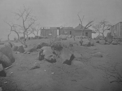
Reprinted from Bailey 1895
One might think it would have been simple enough to correct this error, but as it turned out the two sides were never reconciled, and in the end, Harvard abandoned its Californian ambitions. There remained an irony or two, however. The Pasadena group proceeded with its 40-inch refractor plans and found enough funding to have such a lens actually cast before the funding collapsed and those plans were also abandoned. Later, a Harvard-trained astronomer, George Ellery Hale, persuaded wealthy businessman Charles Yerkes to buy the unused lens for a new observatory established in Yerkes's name and directed by Hale for the University of Chicago.
Subsequently, Hale, under the aegis of the Carnegie Institution of Washington, established an observatory on Wilson's Peak, now known as Mt. Wilson, which after 1918 included a 100-inch telescope with which the likes of Edwin Hubble and Walter Baade would revolutionize modern astronomy. And later, a Mt. Wilson astronomer, Harlow Shapley, became director of the Harvard College Observatory. So in the end, the Southern Californians got the world's largest telescope, while Harvard found satisfaction in its indirect contributions and connections thereto.
Harvard's proposed Southern Hemisphere station got off to a less controversial start. Given the comparative slowness of travel and communications in the late 19th century, Pickering had opted for a site as close to home as possible, and since much of the Pacific coast of South America lies almost due south of Boston, this was the area investigated. Existing weather records indicated that the town of Chosica, some 50 kilometers inland from Lima in Peru, would be a good starting point.
Solon Bailey was the man chosen to lead the expedition. He was then 33 and known for his determination and resourcefulness, having started at the Harvard College Observatory as an unpaid assistant working 40 hours a week. His proven abilities soon led to not only a paying position there, but a master's degree as well. Now, in early 1889, he, with his wife and young son, along with Solon's brother, Marshall, would leave Boston for a two-year journey in South America to choose a site for and establish a southern field station.
Marshall had the unenviable task of shepherding some 100 crates of the expedition's materiel through the journey south, including a crossing of Panama by train. They passed the partly dug canal, on which the De Lesseps Company had recently stopped work, including "the company's hospital and burial ground. The vastness of each bore witness to the power of the forces with which promoters of the canal were obliged to contend.... Decay and desolation" were everywhere, and "a depression will doubtless follow as soon as this enterprise shall be definitely abandoned."
After nearly two months of travel, the party arrived at Chosica and immediately realized that establishing an observatory there was out of the question. The little town, in the verdant valley of the Rimac River, was pleasant, but nearby "abrupt, precipitous mountains" shut out much of the sky. A day or two later Solon and Marshall began scouting the neighboring terrain for a better site. Led by local guides they started off in a northerly direction, passing several well-preserved but long-abandoned settlements. Solon later remarked that "I should place the population of the valley near Chosica in the days of the Incas at six thousand. To-day there are perhaps five hundred. This . . . well illustrates how Peru has changed since she fell into the hands of the Spanish conquerors." The going was extremely arduous, at times "shut in by steep walls that rose a thousand or more feet on either side, the breeze faded away, but the sun beat down with great heat. We followed along the dry bed of what must at some time have been a torrent of tremendous power; for it had worn a rut fifty feet deep into the bed of the ravine, and had brought down great numbers of bowlders, some of enormous size . . . ." Later they were climbing hand and foot a thousand meters or more, until in early afternoon they were atop a mountain they thought would do for their field station. They dubbed it Mount Harvard. "In every direction nothing but barren mountains were to be seen . . . . To the north and south we looked down into gloomy ravines thousands of feet deep." Returning to the hotel in early evening, "we looked back at the dark outline [of Mt. Harvard] against the sky; the thought of a residence on that isolated spot brought a strange sense of gloom and loneliness."
Clearly, they would need much local help in setting up their observatory on Mt. Harvard (or any other mountain in the region), and in any case, they had some misgivings about that site and thought they should seek further weather advice before making a definite decision. So it was that they now returned to Lima for a couple of weeks—first for an audience with the Peruvian President to ask for manual help, and second to consult whatever weather experts they might find in the capital.
The President proved stern but cordial ("with battle-scarred countenance .... his face showed marks of privation and passion") and issued orders "compelling the governor of any province to furnish peons to assist in transporting our instruments." The weather experts, on the other hand, gave much conflicting advice, although the town of Arequipa was mentioned favorably several times, and "Mr. Ralph Abercrombie, the English meteorologist . . . spoke very highly of the Atacama desert [in northern Chile]."
Solon decided to do an initial exploration further up the Rimac Valley, and after returning to Chosica briefly, the brothers set off for Chicla, some 50 kilometers further east. This was no great distance, but they were now climbing ever higher into the Andes and enduring tropical heat.
The road . . . is simply a mule path four feet wide, trailing along the face of the mountain, in many places lofty, steep, and slippery. Frequently it winds around the face of a cliff, cut into the solid rock, and the path worn smooth by innumerable feet for hundreds of years has nothing whatever to prevent the careless from slipping over the side and falling hundreds of feet into the river below. To add to the difficulty, one meets in a day hundreds of laden mules, donkeys, and llamas. The only safety is to insist upon the inside track. Accidents are not rare.
They passed the Verrugas River, a small tributary of the Rimac.
From this river . . . is named the peculiar and dangerous disease known as Verrugas. From it arose a great mortality among [local] workmen. It is still common . . . . The disease is characterized by intense pain, but, especially, by the appearance on different parts of the body of sacs filled with blood. These are sometimes of considerable size, and when the number of them is great, the loss of blood is considerable. Nevertheless, it is regarded as a favorable symptom to have the disease appear on the outside, and medicines are taken to produce this result. It was thought to be caused by drinking Verrugas water . . . .
The following day they breakfasted in San Mateo at an altitude of 3,500 meters, and here Marshall succumbed to his first bout of mountain sickness. It manifested itself by dizziness, faintness, and nausea; complete unconsciousness occurred twice for a few minutes duration. The patient was placed on the ground, and bruised garlic, the odor of which is thought by the natives to have great efficacy, was provided in abundance. A little hot soup, however ... speedily brought the patient into better condition...." Solon's report remarks on the unpredictability of mountain sickness: Later in their travels Marshall had a very serious attack at only 2,100 meters, but three days later at 4,500 meters he experienced only mild dizziness. Solon himself could go to about 5,000 meters without discomfort, but above that he suffered "violent nausea and vomiting, which continued for several hours until I descended to a lower altitude."
However, although this short trip provided "... the wildest ... scenery it has been my privilege to see ... in any country," it revealed no site well suited to an astronomical observatory, and since Pickering was doubtless anxious for some useful work to be done, Solon decided they would set up their equipment on barren Mt. Harvard after all, even though "no supplies were at hand, and all food and water would need to be carried several miles" daily. Mentally, he made a note to himself that during the "mild" cloudy season he had heard about, he and Marshall would explore much farther afield, checking Arequipa and the Atacama Desert among other sites.
The story was far from over. Mt. Harvard had to be abandoned eventually, Pickering made a disastrous mistake that almost aborted the entire project, and Solon and his family found themselves in the midst of a revolution, taken hostage at one point, and later preparing to defend their home with revolvers. I’ll take up that part of the story in my next column.
© J. Donald Fernie
Click "American Scientist" to access home page
American Scientist Comments and Discussion
To discuss our articles or comment on them, please share them and tag American Scientist on social media platforms. Here are links to our profiles on Twitter, Facebook, and LinkedIn.
If we re-share your post, we will moderate comments/discussion following our comments policy.