Icebergs of the Southeast
By David Schoonmaker
During the most recent ice age, huge chunks of ice left gouges in the U.S. continental shelf off the Carolinas
During the most recent ice age, huge chunks of ice left gouges in the U.S. continental shelf off the Carolinas

DOI: 10.1511/2008.75.464
During the last glaciation, sea levels were considerably lower than today, as the “keel” marks of icebergs in the U.S. continental shelf attest. Previously, however, such scours have been found only at middle latitudes and poleward.
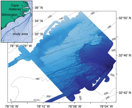
Reporting in a recent issue of Geology, Jenna C. Hill, of Coastal Carolina University, and her colleagues concluded that bergs also wandered southward. Using high-resolution swath bathymetry to reveal the surface of the ocean floor off South Carolina, they interpret the parallel lines shown in the image at left as iceberg scours. The gouges are 10 to 100 meters wide, more than 10 meters deep and exceed 10 kilometers in length. The shallowest of them end at 120 meters depth, ruling out river channels, and they extend out to about the 220-meter line.
These gouges lie about 1,000 kilometers south of the ice margin during the most recent glaciation, and their west-southwest trend suggests that the prevailing current flowed in a different direction then.
From: Hill, Jenna C., Paul T. Gayes, Neal W. Driscoll, Elizabeth A. Johnstone and George R. Sedberry. 2008. Iceberg scours along the southern U.S. Atlantic Margin. Geology 36:447–450.
Click "American Scientist" to access home page
American Scientist Comments and Discussion
To discuss our articles or comment on them, please share them and tag American Scientist on social media platforms. Here are links to our profiles on Twitter, Facebook, and LinkedIn.
If we re-share your post, we will moderate comments/discussion following our comments policy.