How Climate Science Could Lead to Action
By Samantha Jo Fried
Institutional context and history have led to top-down knowledge dissemination. Would infrastructure for public engagement help science lead to mobilization?
Institutional context and history have led to top-down knowledge dissemination. Would infrastructure for public engagement help science lead to mobilization?
Climate change has been an issue of concern for more than 30 years, following a surge of environmentalism in the 1970s. Yet the news surrounding climate change rarely seems to improve, despite growing anxieties about it, as is exemplified by the millions of people across hundreds of countries who participated in the largest climate protest in world history in September 2019.
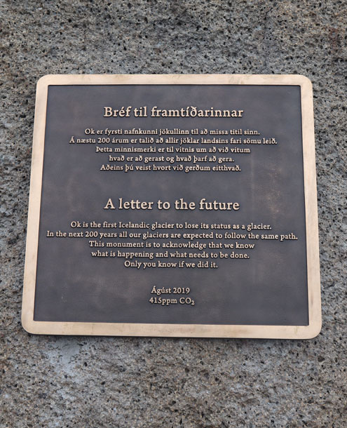
This past summer, Icelandic researchers mourned the loss of the Okjökull glacier “in a funeral of sorts,” as CNN reporter Harmeet Kaur described. A plaque now memorializes the glacier for future generations, acknowledging a collective, global responsibility for anthropogenic climate change. “We know what is happening and know what needs to be done,” the plaque reads in both Icelandic and English. “Only you know if we did it.”
Like climate change itself, Okjökull’s death is neither new nor a surprise (it was actually declared “dead” in 2014). Each summer, it seems—particularly when it is quite hot—there is renewed fear about what the climate will be in 20, 50, or 100 years, and about whether Earth can sustain all that humans demand of it.
Public Lab/CC BY-SA 3.0
There is also significant disagreement about what it will take to protect the most vulnerable among us; to protect sacred lands and national parks; to protect national security interests while living sustainably for the future; to protect an economy that is not built around sustainable practices. Steve Rayner, a social scientist who studies climate policy at Oxford University, notes in an introductory essay to a 2009 book by Mike Hulme that climate change has an “ability to be many things to many people.” This “plasticity,” Rayner says, causes us to remain deeply worried about the looming risks, year after year.
Such plasticity is also a significant source of inertia on climate change. Hulme, a human geographer at the University of Cambridge, observes in his book Why We Disagree about Climate Change that this inaction and discord “reveal, at a deeper level, all that makes for diversity, creativity, and conflict within the human story—our different attitudes to risk, technology and well-being; our different ethical, ideological and political beliefs; our different interpretations of the past and our competing visions of the future.”
Amy McCraig/Rice University
Because there are so many “competing visions of the future,” I will not be so brazen as to tell you which single narrative will help us better reflect on—and solve once and for all—this climate crisis. Regardless of the best course of action, some action is certainly required. To get past the fundamental obstacle of inertia, we need to reflect on how we got here.
One thread that we often ignore within our conversations about climate change is that many of the technologies used to collect and process climate data were originally developed as military countermeasures technologies. That is to say, these satellites and drones—these technologies for remote sensing—were designed to provide a small group of experts with information on enemy whereabouts, and then deploy weaponry. To be sure, we have not properly reflected on the morality of this usage (and descendants of these countermeasures technologies are still features of war-fighting in the present).
NASA Earth Observatory by Joshua Stevens/Landsat data from U. S. Geological Survey
My research, however, does not yet take up issues of morality directly (although I acknowledge the importance of such issues). My research takes up an adjacent issue: the functionality of Earth remote sensing as a technology of war-fighting.
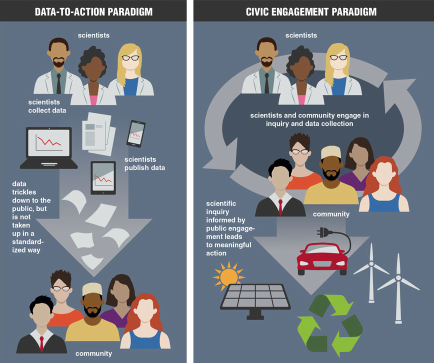
The technologies we use to collect data on climate—an emergent issue that spans many moments across space and time—originated as technologies that assessed a battlefield and deployed weaponry, in an instant, in one place. However, there is no automatic deployment solution for climate change. There is no small group of experts who can realistically attend to the whole of the problem. Yet we who are concerned about climate change often find ourselves stuck in the language of automatic deployment; of small groups of experts; of top-down action. We do this every time we assume that more Earth data or better science will lead to action on climate. I call this assumption that more data will lead to more action the data-to-action paradigm.
I trace the data-to-action paradigm, or the overfocus on digital Earth data as the foremost cure to our climate ills, to Earth remote sensing technologies, which are the major way we visualize—or, as Hulme says, “create iconographies for”—climate change. In his aforementioned book, Hulme explores the history of our “domestication” of climate: of its measurement and quantification. Indeed, Earth remote sensing technologies such as satellites are our primary mode of climate domestication. We use these technologies to bring climate to us, and to recreate it as understandable and predictable. “It is not surprising,” Paul Edwards of the University of Michigan remarks in his 2001 book, “that with its analytical roots so firmly planted in meteorology, the dominant popular understanding of climate therefore remains [a] numerical and statistical one.”
Meteorological satellites share capabilities with Earth remote sensing satellites that help us understand features of Earth’s system and relate them to larger-scale problems such as climate change. The “gold standard” for this technology is Landsat, often referred to as the United States’ first civilian Earth remote sensing satellite. However, Landsat and other satellites like it are not as civilian in origin as one might think. Landsat in particular owes its scanning instrument to a defense-funded laboratory at the University of Michigan: Willow Run Laboratories. This instrument developed out of multiple iterations of war-fighting technologies.
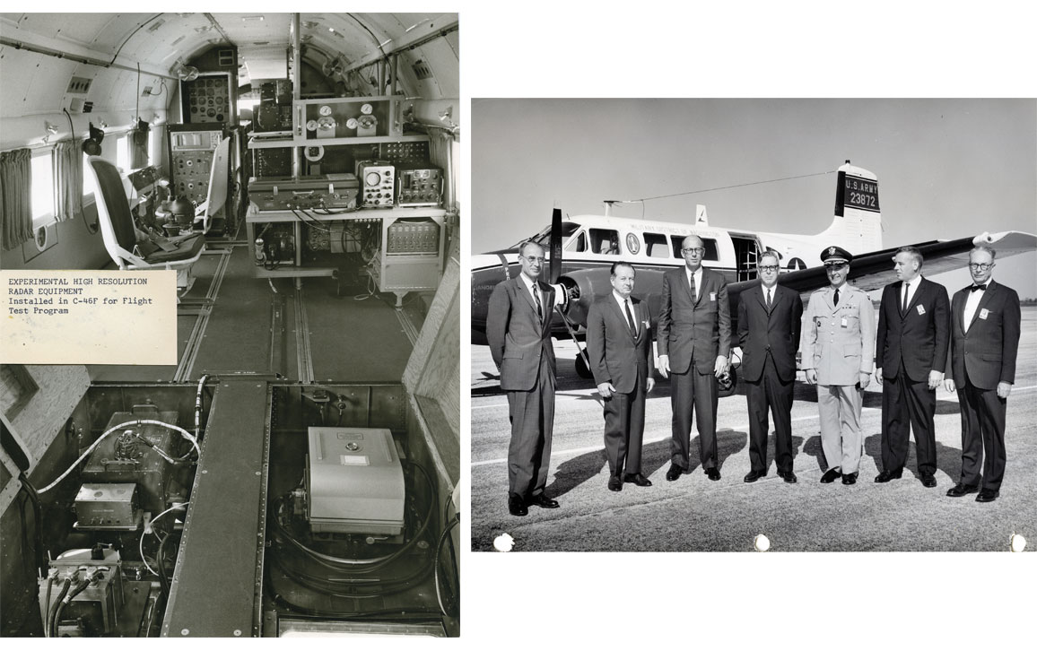
James T. Wilson papers 1940–1978/Bentley Historical Library, University of Michigan
Willow Run’s earliest project was related to the V-2 missile. “V-2” stands for the German word vergeltungswaffen: waffen meaning weapon, and vergeltung meaning retaliation. These retaliatory weapons were semiautonomous missiles, capable of vast amounts of destruction. Germany deployed these weapons toward the end of World War II, in an attempt to gain some momentum despite an impending loss. After the war, Allied powers including the United States feared the destructive capabilities of the V-2. So the U.S. Department of Defense supplied a great deal of funding to laboratories such as Willow Run to create more advanced missiles capable of shooting down the V-2.
A series of autonomous battlefield technologies followed Willow Run’s work countering the V-2, the most successful of which was Project Michigan. Developed in 1953, Project Michigan was, in the words of the late illustrious electrical engineer William Dow, “a large-scale tri-service program in battlefield surveillance.” Here, “tri-service” means that Project Michigan could detect, identify, and deploy. Michigan was an instrument that could scan a battlefield, identify an enemy force (even one in hiding), and automatically deploy weaponry.
Ten years later, scientists and engineers at Willow Run built their first multispectral scanner. These researchers aimed to create imagery more complex than the radar-based kind from Project Michigan: imagery that involved a combination of spectral bands. To understand this multispectral scanner and its spectral bands, consider that what we see with our eyes constitutes only a very small piece of the electromagnetic spectrum: that of visible light. However, with the aid of multispectral scanners, researchers can view ultraviolet light, for example, or infrared light. This ability to view light in different wavelengths has applications beyond the battlefield.
Infrared images in particular can provide Earth systems researchers with insights about the health and leafiness of trees, and they can meaningfully depict water loss and evaporation in drought-prone areas. These kinds of findings are part and parcel of our research on the changing climate. Infrared remote sensing of the environment is an essential part of Earth systems research, and of our understanding of climate change. That we use infrared sensing for these environmental purposes, however, is a happy accident. Infrared imaging was initially developed for military applications, for distinguishing enemy troops or tanks from their surrounding environment, or seeing them through fog or dust. Infrared sensing also helps troops navigate battlefields at night. And, to be clear, Willow Run was not the only laboratory conducting this type of research.
If we wish to prioritize collective, grassroots action on environmental issues, we must rethink our relationship to Earth remote sensing satellites.
Willow Run, though, was unique in its particular development of the multispectral scanner. This type of scanner is the basis of much of our Earth remote sensing data today and is crucial to Earth systems research. Willow Run built its multispectral scanner using parts from battlefield surveillance giant Project Michigan, as well as infrared scanners borrowed from the U.S. Army. Yet this multispectral scanner was not positioned as a military project.
Willow Run’s multispectral scanner was adopted by the National Aeronautics and Space Administration (NASA) in 1972 and was flown on board the first Earth Resources Technology Satellite (ERTS-1). The ERTS-1 mission is better known now as the first Landsat mission. Landsat’s website advertises that “[e]very day, Landsat satellites provide essential information to help land managers and policy makers make wise decisions about our resources and our environment.”
To be clear, I do not interpret this history as a technological determinist, who might say something like: “Earth remote sensing technologies began as war-fighting technologies and therefore will always be war-fighting technologies.” Rather, I interpret that this history tells us something about the inclinations of Earth remote sensing technologies. They lend themselves to expert-led decision-making at a moment (or a series of moments) in time, and not to issues such as climate change, which is both local and global, and which requires public action at a variety of scales.
If more Earth remote sensing data won’t lead to public engagement with—and clearer action on—issues of climate change, what will? Earth remote sensing technologies are still crucial to our understanding of Earth systems at many scales. However, if we wish to prioritize collective, grassroots action on environmental issues, we must rethink our relationship to these technologies and their data. The impetus for change must come from an engaged public.
The impetus for change must come from an engaged public.
I call this reconfiguration the civic engagement paradigm. I take my cues for this new paradigm, particularly, from Peter Levine’s 2013 book We Are the Ones We Have Been Waiting For, from the concept of prophetic pragmatism by philosopher Cornel West, and from the work of scholars such as Sara Wylie of Northeastern University and Max Liboiron of Memorial University in Newfoundland.
Laying out a civic engagement paradigm requires me to do something that I am not entirely comfortable with and that I, as an academic in a critical field, am trained to be skeptical of: It requires me to provide you with some goal-oriented recommendations for collective action. To be sure, I am skeptical of approaches that are purely solution-oriented. I fear that an overemphasis on outcomes can lull us into a false sense of effectiveness and can cause us to establish certain “achievable” goals surrounding action on climate change (such as collecting more data or recycling) that don’t actually address the complexity of the problem.
Barbara Aulicino
In short, it would be irresponsible for me to guide you further into the belief, if it is indeed a belief that you already hold, that we should only organize around systems that will provide us with measurable, achievable outcomes. These are never as certain as we assume they are. For instance, we can never be sure that our solutions to climate change will address a geographically and culturally heterogeneous group of people; will pay real (and not lip service) attention to those of us who have been systematically excluded; will take uncertainty into account; or will be adaptable to the unexpected.
Yet there is another extreme that we in the academy sometimes occupy. We are trained to make theoretically sound critiques or to collect statistically significant findings that speak to strong methodological commitments. We are trained to design and use awe-inspiring satellites. Many of us, however, are not trained to make interventions. Interventions are messy and require making mistakes. They are uncertain. This uncertainty about effective interventions is particularly hard to admit in our current political climate, in which it feels as though there is little trust between academic spaces and the communities within which they sit.
I want to look into this weakness that I know exists within my academic background. But I also don’t know exactly where we ought to go with respect to this civic engagement paradigm. However, I can offer some pathways that I currently believe in. They will not be fix-alls, and you should not buy into them completely as ultimate solutions. Rather, they are starting points, suggestions that should be critiqued and modified, and that should be adapted to different situations. I know that I risk perpetuating the data-to-action paradigm if I do not, at least, offer up some ways forward.
In discussing the civic engagement paradigm, I am attempting to take up something political philosopher Cornel West, currently at Harvard University and professor emeritus at Princeton University, has termed prophetic pragmatism. “Prophetic pragmatism is pragmatism at its best,” writes West, “because it promotes a critical temper and democratic faith without making criticism a fetish or democracy an idol.” In other words, we should always be critical of our engagement with climate change, constantly striving to situate that engagement in political and social contexts. We can keep this critical lens while seeking to take action on the issue in meaningful ways.
To do that, we need examples of new ways of doing science, imagining how they might apply more broadly. In other words, I consider the civic engagement paradigm of Earth remote sensing data to be a kind of sociotechnical imaginary, as termed by Sheila Jasanoff of Harvard University (see a Q&A with her in the July–August 2017 issue) and Sang-Hyun Kim of Hanyang University in South Korea. As Jasanoff and Kim write in their 2009 article, sociotechnical imaginaries are “collectively imagined forms of social life and social order reflected in the design and fulfillment of nation-specific scientific and/or technological projects,” that “at once describe attainable futures and prescribe futures that states believe ought to be attained.” Sociotechnical imaginaries can help us visualize (and perhaps even create iconographies of) action-oriented public engagement with Earth remote sensing technologies.
In the civic engagement paradigm, matters of public concern would inform data and models in cyclical ways.
The concept of sociotechnical imaginaries is useful because it invokes a focus that doesn’t fetishize (to use West’s terminology) criticism or measurable outcomes. Rather, it is about imagining alternative futures. That is what we need when speaking about climate change, as our current configuration of measurable outcomes and criticism hasn’t worked for us thus far.
The new imaginary, which I am calling the civic engagement paradigm, is one in which civic engagement is prioritized in our iconographies of climate change. In this paradigm, expert research—that is, the work of climate scientists, Earth systems scientists, and researchers in relevant areas of Earth remote sensing, as well as conversations around climate change more generally—would be guided by a different set of concerns. These concerns would depart from the technocratic perspective: one in which we ask what data and models tell us to do. Rather, matters of civic concern (to modify terminology by Bruno Latour of the Paris Institute of Political Studies) would inform data and models— and the machines that create them—in cyclical ways.
Two examples of science oriented toward the communities they work with can help us imagine this new paradigm and ask questions about how they might be applied more broadly.
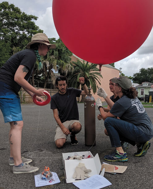
Public Lab, a nonprofit based in Atlanta, Georgia (with locations in New York City and New Orleans), was founded to promote civic-led engagement with Earth remote sensing technologies. Their website notes that “during the [2010 BP oil] spill, there was an information blackout for residents of the coastal region, as well as the rest of the world. No one was accurately tracking what was happening on the ground. In response a group of concerned residents, environmental advocates, designers, and social scientists lofted ‘community satellites,’ made from balloons, kites and digital cameras, over the spill to collect real time data.”
Public Lab continues to facilitate these do-it-yourself Earth remote sensing projects in the form of balloon or kite mapping (and has expanded beyond remote sensing to offer other forms of civic data collection). Balloon mapping is homemade aerial photography, and can be simple or advanced. One can make a balloon mapping instrument from scratch or purchase a ready-made kit. Public Lab also hosts a community atlas called MapKnitter, into which enthusiasts can upload their DIY aerial imagery. And although it’s still hard to imagine someone without an inclination for the very technical participating in such a project, it is remarkable to see this type of engagement occurring outside of a laboratory or a university.
These projects exemplify Public Lab’s stated mission “to open research from the exclusive hands of scientific experts,” so that “communities facing environmental justice issues are able to own the science and advocate for the changes they want to see.” Public Lab blurs the divide between experts and publics through a free and open online forum. On this forum page, anyone can ask a scientific question meaningful to their community—a question that they alone do not have the expertise or resources to address. Then, other Public Lab forum members can respond with relevant information, know-how, and suggestions.
For example, a tutorial on Landsat data posted by forum members in 2014 is meant to help motivated members of the community learn this skill outside of a university or lab. Landsat data are currently free and open source (although they were not always). However, one does not simply download and analyze Landsat data (to invoke the meme that references The Lord of the Rings). This process requires a substantial level of expertise, including knowledge of proprietary software, programming languages, the physics of spectral scanning, statistics, geography, and map reading. And although a public tutorial cannot instantly bestow all this expertise on even the most curious learners, it is an important step in the right direction. It remains an open question what the best way is to bridge the gap between people who need information (or want to contribute to data-driven solutions) and people with the expertise to cocreate that knowledge.
Nevertheless, Public Lab has demonstrated that this approach can work: It enabled the documentation of more than 10,000 photographs of the 2010 oil spill at a far lower price and higher resolution than satellite imagery could offer, including images of wetlands before and after the spill had reached the shore. These photos were disseminated to journalists to provide real-time information to the public, bypassing the information blackout. Such photographs can be used during litigations related to the oil spill.
Located in Newfoundland, Canada, the Civic Laboratory for Environmental Action Research (CLEAR) is an interdisciplinary collective of researchers, some of whom are academically affiliated. The lab strives to incorporate indigenous and feminist ways of knowing into its grassroots projects, balancing resources and space at Memorial University with community-level engagement. For instance, one of CLEAR’s projects is an ongoing community peer review of research on plastic’s effects on ecosystems. CLEAR’s website reads:
When we have obtained findings about plastic in wild food webs, particularly [in] food consumed by humans, we hold a public meeting in the communities that samples came from. We discuss our methods and findings, and ask community members for their input, criticism, insights, and concerns. This strengthens our research findings through the contributions of local expertise, but more importantly, is an opportunity for communities to impact how (and whether) [the] research circulates beyond that meeting.
Researchers from CLEAR have even developed methodologies for community peer review that others can adopt (in their 2018 article “Community peer review: A method to bring consent and self-determination into the sciences”). This methodology begins with the premise that “research is not inherently good and can cause harm, and that the best people to know whether and what kinds of harms are likely to occur are community members rather than researchers.” CLEAR’s methodology makes room for community consent and community refusal. Furthermore, this community peer review technique implores researchers to hire community members at the outset of research.
CLEAR and its affiliate researchers also have a few projects that are directly related to Earth remote sensing techniques or are quite adjacent. Consider their open-source thermal flashlight (http://bit.ly/thermal-flashlights), which utilizes the same infrared technology discussed earlier. “The light ‘paints’ surface temperatures directly onto the materials under examination, making the data easy to understand,” reads the project website.
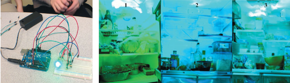
Max Liboiron (left); SAGE Publications
Catherine Kenny, an independent scholar in Toronto, published an article alongside Liboiron (founder of CLEAR, in addition to her affiliation with Memorial University) and Wylie on this same project. Kenny, Liboiron, and Wylie taught students with no prior experience in engineering or physics how to build these thermal infrared flashlights. Their reasoning for such a project? “The environmental problems we face in the twenty-first century are dispersed, often difficult to see, and are part of both local and global infrastructural arrangements, making collaborations between disciplines, types of expertise, and geographical locations essential,” they write in their 2019 article in Social Studies of Science.
Kenny, Liboiron, and Wylie conclude that the takeaway from the project was not merely that students learned to build their own thermal infrared sensing device, but also that they learned to “[link] learning to research to action by making connections between artifacts, infrastructures and power”; learned that there is no “‘correct’ technological design,” but rather “appropriate” designs for different circumstances and research questions at hand; learned to begin a project “that started in their own lived experiences but scaled up to infrastructure and wider social relations”; and learned to conduct action-oriented research, in which “we are already doing something about the problems in front of us, as we investigate them.”
In one case that they write about, undergraduate students compared temperature variation among refrigerators around campus and living spaces, identifying one refrigerator on their campus with particularly poor temperature regulation. When they looked into that model of refrigerator, they found it had been discontinued because it had problems maintaining a set temperature. This finding raised questions about their university’s health and safety standards. Such small, actionable revelations in a classroom project can scale up as students learn from these experiences.
Organizations such as CLEAR and Public Lab can serve as sociotechnical imaginaries—starting places for imagining new ways of doing science in our own locations—for what collaborative research and public engagement could look like, beyond its current existence. We could ask what a strictly community-based research space would look like in Radford, Virginia, versus in Worcester, Massachusetts. How might those different spaces need to be built to best meet the needs of the communities they would serve? How might those involved with such spaces engage philanthropists, or nearby colleges or universities, if they are in need of money or other resources? What kinds of research questions might they engage with if they are to earn the trust of the communities they work for and with—including underserved communities or indigenous groups? These inquiries might seem pie-in-the-sky, particularly in relation to our current modes of climate modeling and Earth systems research. But these questions can lead to more effective modes of grappling with climate change.
Although I believe CLEAR and Public Lab present us with fruitful imaginaries for grassroots engagement with climate change through Earth remote sensing technologies, I know these efforts will look different when applied to a variety of geographic, political, and sociocultural needs. I also know that they would morph and mutate when members of such communities began to express needs around them. But this variation would be a very good thing. As Levine writes in his book We Are the Ones We Have Been Waiting For, “People often don’t know what they want until they have communicated with others.”
Despite the necessity of this variation, I’ve come to see that the uncertainty of these kinds of endeavors often keeps them from gaining traction or becoming funded in predictable ways. To have more initiatives like CLEAR and Public Lab, we will need to reconfigure our relationships to public funding structures, philanthropic engagement, institutions of higher education, and more.
When framed this way, climate change becomes a slow, long-term engagement for which data collection is only a tiny piece. What is required is a complete reorientation of the ways in which we create knowledge, conceive of our livelihoods, and consider each other.
Click "American Scientist" to access home page
American Scientist Comments and Discussion
To discuss our articles or comment on them, please share them and tag American Scientist on social media platforms. Here are links to our profiles on Twitter, Facebook, and LinkedIn.
If we re-share your post, we will moderate comments/discussion following our comments policy.